Date geodata
Date (Hokkaido) is a seat of a second-order administrative division; located in Japan in Asia/Tokyo (GMT+9) time zone. With population of 35,301 people, there are 496 cities with bigger population in this country. Compared to other cities in Japan, 96.1% of cities are located further ↓South; 91.7% of cities are located further ←West and 86% of cities have higher elevation than Date. Note1


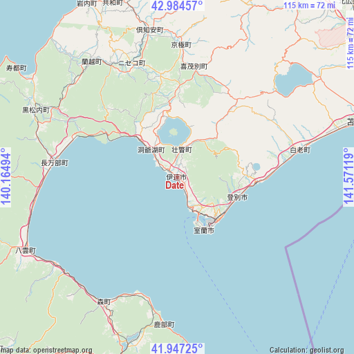
Date GPS coordinates[2]
42° 28' 5.016" North, 140° 52' 5.016" East
| Map corner | latitude | longitude |
|---|---|---|
| Upper-left | 42.98457°, | 140.16494° |
| Center: | 42.46806°, | 140.86806° |
| Lower-right: | 41.94725°, | 141.57119° |
| Map W x H: | 115.3×115.3 km | = 71.6×71.6mi |
| max Lat: | 45.40944° ⇑3.9% North |
| Date: | 42.46806° |
| min Lat: | ⇓96.1% South 24.34478° |
| min Long | Date | max Long |
| 123° | 140.86806° | 145.575° |
| W 91.7%⇐ | ⇒8.3% E |
Elevation
Elevation of Date is 6 m = 20 ft, and this is 78.6 m = 258 ft below average elevation for this country.
| Max E: |
1086 m = 3563 ft | 86% |
| Avg. | 84.6 m = 278 ft | |
| Date | 6 m = 20 ft | |
Min E: |
-2 m = -7 ft | 14% |
See also: Japan elevation on elevation.city.
Geographical zone
Date is located in North temperate zone (between Tropic of Cancer and the Arctic Circle). Distance of this Northern Tropic circle is 2116.1 km =1314.9 mi to South.| Distance of | km | miles | from Date |
|---|---|---|---|
| North Pole | 5285.1 | 3284 | to North |
| Arctic Circle | 2679.2 | 1664.8 | to North |
| Tropic Cancer | 2116.1 | 1314.9 | to South |
| Equator | 4722 | 2934.1 | to South |


Nearby cities:
15 places around Date: (largest is in red/bold)
• Chitose
75.1 km =46.7 mi,  58°
58°
• Eniwa
74.7 km =46.4 mi,  50°
50°
• Hakodate
77.7 km =48.3 mi,  188°
188°
• Hokuto
75 km =46.6 mi, 194°
• Honchō
65.4 km =40.6 mi, 192°
• Iwanai
63.5 km =39.5 mi,  332°
332°
• Kamiiso
74.4 km =46.2 mi, 194°
• Kitahiroshima
80.3 km =49.9 mi, 45°
• Muroran
19.5 km =12.1 mi,  149°
149°
• Niseko Town
38.2 km =23.7 mi, 334°
• Noboribetsu
25.6 km =15.9 mi,  93°
93°
• Otaru
81 km =50.3 mi,  7°
7°
• Sapporo
77.3 km =48 mi,  30°
30°
• Shiraoi
40.5 km =25.2 mi,  77°
77°
• Tomakomai
63.1 km =39.2 mi,  72°
72°
Sources, notices
• [Note1] Compared only with cities in Japan existing in our database
• [Src1] Map data: © OpenStreetMap contributors (CC-BY-SA)
• [Src2] Other city data from geonames.org with taken over terms of usage.
• [Src3] Geographical zone / Annual Mean Temperature by Robert A. Rohde @ Wikipedia
