Muroran geodata
Muroran (Hokkaido) is a seat of a second-order administrative division; located in Japan in Asia/Tokyo (GMT+9) time zone. With population of 96,197 people, there are 211 cities with bigger population in this country. Compared to other cities in Japan, 95.8% of cities are located further ↓South; 92.6% of cities are located further ←West and 79% of cities have higher elevation than Muroran. Note1


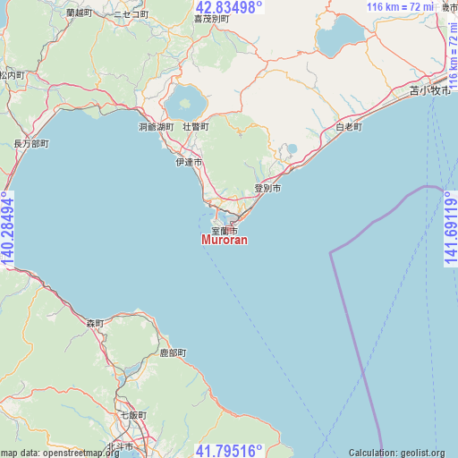
Muroran GPS coordinates[2]
42° 19' 1.992" North, 140° 59' 17.016" East
| Map corner | latitude | longitude |
|---|---|---|
| Upper-left | 42.83498°, | 140.28494° |
| Center: | 42.31722°, | 140.98806° |
| Lower-right: | 41.79516°, | 141.69119° |
| Map W x H: | 115.6×115.6 km | = 71.8×71.8mi |
| max Lat: | 45.40944° ⇑4.2% North |
| Muroran: | 42.31722° |
| min Lat: | ⇓95.8% South 24.34478° |
| min Long | Muroran | max Long |
| 123° | 140.98806° | 145.575° |
| W 92.6%⇐ | ⇒7.4% E |
Elevation
Elevation of Muroran is 8 m = 26 ft, and this is 76.6 m = 251 ft below average elevation for this country.
| Max E: |
1086 m = 3563 ft | 79% |
| Avg. | 84.6 m = 278 ft | |
| Muroran | 8 m = 26 ft | |
Min E: |
-2 m = -7 ft | 21% |
See also: Muroran elevation on elevation.city.
Geographical zone
Muroran is located in North temperate zone (between Tropic of Cancer and the Arctic Circle). Distance of this Northern Tropic circle is 2099.3 km =1304.4 mi to South.| Distance of | km | miles | from Muroran |
|---|---|---|---|
| North Pole | 5301.8 | 3294.4 | to North |
| Arctic Circle | 2695.9 | 1675.2 | to North |
| Tropic Cancer | 2099.3 | 1304.4 | to South |
| Equator | 4705.2 | 2923.7 | to South |


Nearby cities:
15 places around Muroran: (largest is in red/bold)
• Chitose
77.9 km =48.4 mi,  44°
44°
• Date
19.5 km =12.1 mi,  329°
329°
• Eniwa
80.1 km =49.8 mi, 36°
• Hakodate
63.7 km =39.6 mi,  199°
199°
• Hokuto
62.9 km =39.1 mi,  207°
207°
• Honchō
52.9 km =32.9 mi, 207°
• Iwanai
82.9 km =51.5 mi, 331°
• Kamiiso
62.1 km =38.6 mi, 207°
• Kitahiroshima
87.2 km =54.2 mi,  32°
32°
• Niseko Town
57.6 km =35.8 mi, 333°
• Noboribetsu
21.7 km =13.5 mi,  46°
46°
• Otaru
97 km =60.3 mi,  0°
0°
• Sapporo
88.4 km =54.9 mi,  19°
19°
• Shiraoi
39.4 km =24.5 mi, 48°
• Tomakomai
61.7 km =38.3 mi, 54°
Sources, notices
• [Note1] Compared only with cities in Japan existing in our database
• [Src1] Map data: © OpenStreetMap contributors (CC-BY-SA)
• [Src2] Other city data from geonames.org with taken over terms of usage.
• [Src3] Geographical zone / Annual Mean Temperature by Robert A. Rohde @ Wikipedia
