Hirakata geodata
Hirakata (Ōsaka) is a seat of a second-order administrative division; located in Japan in Asia/Tokyo (GMT+9) time zone. With population of 406,331 people, there are 36 cities with bigger population in this country. Compared to other cities in Japan, 64% of cities are located further ↑North; 64.9% of cities are located further →East and 62.8% of cities have higher elevation than Hirakata. Note1


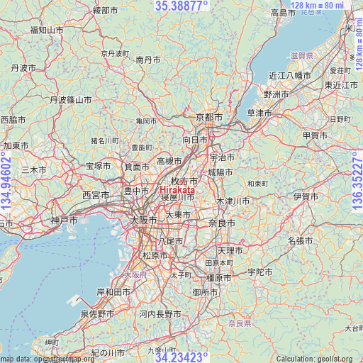
Hirakata GPS coordinates[2]
34° 48' 48.672" North, 135° 38' 56.904" East
| Map corner | latitude | longitude |
|---|---|---|
| Upper-left | 35.38877°, | 134.94602° |
| Center: | 34.81352°, | 135.64914° |
| Lower-right: | 34.23423°, | 136.35227° |
| Map W x H: | 128.4×128.4 km | = 79.8×79.8mi |
| max Lat: | 45.40944° ⇑64% North |
| Hirakata: | 34.81352° |
| min Lat: | ⇓36% South 24.34478° |
| min Long | Hirakata | max Long |
| 123° | 135.64914° | 145.575° |
| W 35.1%⇐ | ⇒64.9% E |
Elevation
Elevation of Hirakata is 17 m = 56 ft, and this is 67.6 m = 222 ft below average elevation for this country.
| Max E: |
1086 m = 3563 ft | 62.8% |
| Avg. | 84.6 m = 278 ft | |
| Hirakata | 17 m = 56 ft | |
Min E: |
-2 m = -7 ft | 37.2% |
See also: Hirakata elevation on elevation.city.
Geographical zone
Hirakata is located in North temperate zone (between Tropic of Cancer and the Arctic Circle). Distance of this Northern Tropic circle is 1265 km =786 mi to South.| Distance of | km | miles | from Hirakata |
|---|---|---|---|
| North Pole | 6136.2 | 3812.9 | to North |
| Arctic Circle | 3530.3 | 2193.6 | to North |
| Tropic Cancer | 1265 | 786 | to South |
| Equator | 3870.9 | 2405.3 | to South |


Nearby cities:
15 places around Hirakata: (largest is in red/bold)
• Daitōchō
11.4 km =7.1 mi,  193°
193°
• Ibaraki
7.4 km =4.6 mi,  272°
272°
• Jōyō
14.7 km =9.1 mi,  76°
76°
• Kadoma
10.8 km =6.7 mi,  219°
219°
• Katano
4 km =2.5 mi,  123°
123°
• Kyōtanabe
10.8 km =6.7 mi,  95°
95°
• Moriguchi
11.7 km =7.3 mi, 220°
• Nagaoka
13.6 km =8.5 mi,  16°
16°
• Neyagawa
5.6 km =3.5 mi,  200°
200°
• Settsu
6.3 km =3.9 mi,  231°
231°
• Shijōnawate
9.4 km =5.8 mi,  160°
160°
• Suita
13.5 km =8.4 mi,  244°
244°
• Takatsuki
4.9 km =3 mi,  322°
322°
• Tanabe
10.7 km =6.6 mi, 84°
• Yawata
8 km =5 mi,  37°
37°
Sources, notices
• [Note1] Compared only with cities in Japan existing in our database
• [Src1] Map data: © OpenStreetMap contributors (CC-BY-SA)
• [Src2] Other city data from geonames.org with taken over terms of usage.
• [Src3] Geographical zone / Annual Mean Temperature by Robert A. Rohde @ Wikipedia
