Tsurugashima geodata
Tsurugashima (Saitama) is a seat of a second-order administrative division; located in Japan in Asia/Tokyo (GMT+9) time zone. In our database, there are 767 cities with bigger population. Compared to other cities in Japan, 66.3% of cities are located further ↓South; 66.4% of cities are located further ←West and 53.8% of cities have lower elevation than Tsurugashima. Note1


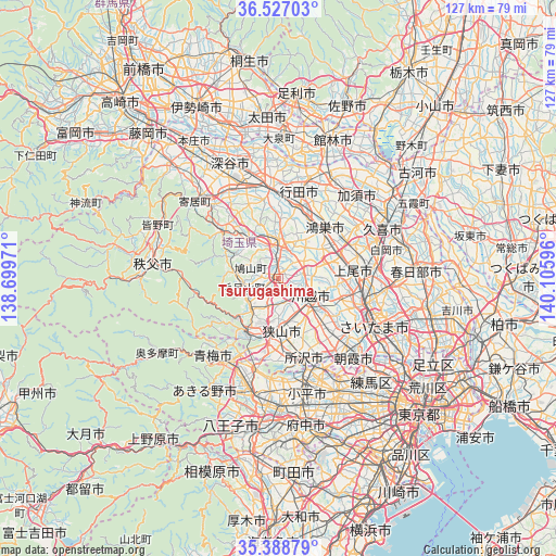
Tsurugashima GPS coordinates[2]
35° 57' 35.856" North, 139° 24' 10.188" East
| Map corner | latitude | longitude |
|---|---|---|
| Upper-left | 36.52703°, | 138.69971° |
| Center: | 35.95996°, | 139.40283° |
| Lower-right: | 35.38879°, | 140.10596° |
| Map W x H: | 126.6×126.6 km | = 78.7×78.7mi |
| max Lat: | 45.40944° ⇑33.7% North |
| Tsurugashima: | 35.95996° |
| min Lat: | ⇓66.3% South 24.34478° |
| min Long | Tsurugashima | max Long |
| 123° | 139.40283° | 145.575° |
| W 66.4%⇐ | ⇒33.6% E |
Elevation
Elevation of Tsurugashima is 33 m = 108 ft, and this is 51.6 m = 169 ft below average elevation for this country.
| Max E: |
1086 m = 3563 ft | 46.2% |
| Avg. | 84.6 m = 278 ft | |
| Tsurugashima | 33 m = 108 ft | |
Min E: |
-2 m = -7 ft | 53.8% |
See also: Japan elevation on elevation.city.
Geographical zone
Tsurugashima is located in North temperate zone (between Tropic of Cancer and the Arctic Circle). Distance of this Northern Tropic circle is 1392.5 km =865.3 mi to South.| Distance of | km | miles | from Tsurugashima |
|---|---|---|---|
| North Pole | 6008.7 | 3733.6 | to North |
| Arctic Circle | 3402.8 | 2114.4 | to North |
| Tropic Cancer | 1392.5 | 865.3 | to South |
| Equator | 3998.4 | 2484.5 | to South |


Nearby cities:
15 places around Tsurugashima: (largest is in red/bold)
• Fujimino
14.9 km =9.3 mi,  137°
137°
• Fukiage-fujimi
16.1 km =10 mi,  15°
15°
• Hannō
14.2 km =8.8 mi,  212°
212°
• Hidaka
6 km =3.7 mi,  217°
217°
• Higashi-Matsuyama
8.3 km =5.2 mi,  8°
8°
• Iruma
16.1 km =10 mi,  191°
191°
• Kamifukuoka
13.9 km =8.6 mi,  134°
134°
• Kawagoe
9.4 km =5.8 mi, 127°
• Kitamoto
14.6 km =9.1 mi,  56°
56°
• Kōnosu
15.9 km =9.9 mi,  40°
40°
• Morohongō
9.3 km =5.8 mi,  252°
252°
• Okegawa
14.6 km =9.1 mi,  72°
72°
• Sakado
1.3 km =0.8 mi,  255°
255°
• Sayama
11.9 km =7.4 mi,  175°
175°
• Ōi
16.1 km =10 mi, 138°
Sources, notices
• [Note1] Compared only with cities in Japan existing in our database
• [Src1] Map data: © OpenStreetMap contributors (CC-BY-SA)
• [Src2] Other city data from geonames.org with taken over terms of usage.
• [Src3] Geographical zone / Annual Mean Temperature by Robert A. Rohde @ Wikipedia
