Kawagoe geodata
Kawagoe (Saitama) is a seat of a second-order administrative division; located in Japan in Asia/Tokyo (GMT+9) time zone. With population of 337,931 people, there are 56 cities with bigger population in this country. Compared to other cities in Japan, 65.3% of cities are located further ↓South; 68.6% of cities are located further ←West and 52.3% of cities have higher elevation than Kawagoe. Note1


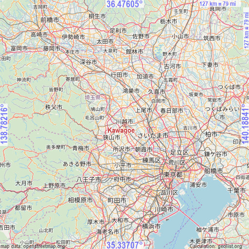
Kawagoe GPS coordinates[2]
35° 54' 30.996" North, 139° 29' 7.008" East
| Map corner | latitude | longitude |
|---|---|---|
| Upper-left | 36.47605°, | 138.78216° |
| Center: | 35.90861°, | 139.48528° |
| Lower-right: | 35.33707°, | 140.18841° |
| Map W x H: | 126.6×126.6 km | = 78.7×78.7mi |
| max Lat: | 45.40944° ⇑34.7% North |
| Kawagoe: | 35.90861° |
| min Lat: | ⇓65.3% South 24.34478° |
| min Long | Kawagoe | max Long |
| 123° | 139.48528° | 145.575° |
| W 68.6%⇐ | ⇒31.4% E |
Elevation
Elevation of Kawagoe is 26 m = 85 ft, and this is 58.6 m = 192 ft below average elevation for this country.
| Max E: |
1086 m = 3563 ft | 52.3% |
| Avg. | 84.6 m = 278 ft | |
| Kawagoe | 26 m = 85 ft | |
Min E: |
-2 m = -7 ft | 47.7% |
See also: Kawagoe elevation on elevation.city.
Geographical zone
Kawagoe is located in North temperate zone (between Tropic of Cancer and the Arctic Circle). Distance of this Northern Tropic circle is 1386.7 km =861.7 mi to South.| Distance of | km | miles | from Kawagoe |
|---|---|---|---|
| North Pole | 6014.4 | 3737.2 | to North |
| Arctic Circle | 3408.5 | 2117.9 | to North |
| Tropic Cancer | 1386.7 | 861.7 | to South |
| Equator | 3992.7 | 2480.9 | to South |


Nearby cities:
15 places around Kawagoe: (largest is in red/bold)
• Ageoshimo
13.5 km =8.4 mi,  58°
58°
• Fujimi
9.2 km =5.7 mi,  136°
136°
• Fujimino
5.9 km =3.7 mi,  152°
152°
• Hidaka
11.1 km =6.9 mi,  274°
274°
• Kamifukuoka
4.7 km =2.9 mi, 147°
• Kitamoto
14.6 km =9.1 mi,  18°
18°
• Niiza
11.7 km =7.3 mi, 146°
• Okegawa
12 km =7.5 mi,  32°
32°
• Sakado
10.2 km =6.3 mi,  301°
301°
• Sayama
9 km =5.6 mi,  226°
226°
• Shiki
12.2 km =7.6 mi,  133°
133°
• Tokorozawa
12.3 km =7.6 mi,  186°
186°
• Tsurugashima
9.4 km =5.8 mi,  307°
307°
• Yono
13.6 km =8.5 mi,  101°
101°
• Ōi
7.1 km =4.4 mi, 154°
Sources, notices
• [Note1] Compared only with cities in Japan existing in our database
• [Src1] Map data: © OpenStreetMap contributors (CC-BY-SA)
• [Src2] Other city data from geonames.org with taken over terms of usage.
• [Src3] Geographical zone / Annual Mean Temperature by Robert A. Rohde @ Wikipedia
