Okegawa geodata
Okegawa (Saitama) is a seat of a second-order administrative division; located in Japan in Asia/Tokyo (GMT+9) time zone. With population of 75,062 people, there are 265 cities with bigger population in this country. Compared to other cities in Japan, 67.5% of cities are located further ↓South; 70.5% of cities are located further ←West and 56.6% of cities have higher elevation than Okegawa. Note1


Okegawa GPS coordinates[2]
36° 0' 0" North, 139° 33' 25.992" East
| Map corner | latitude | longitude |
|---|---|---|
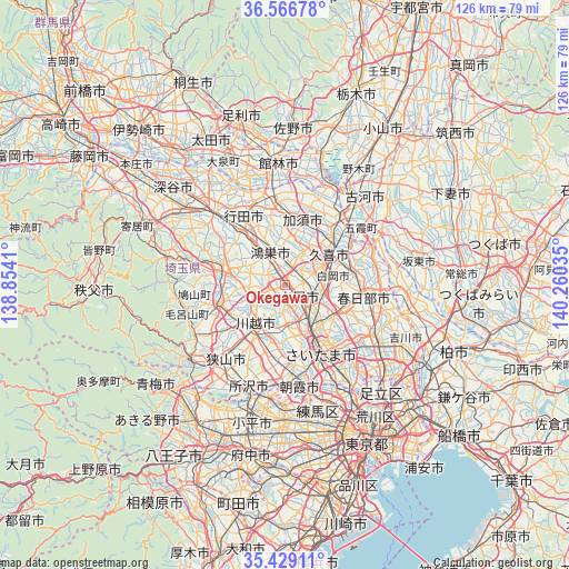
| Upper-left | 36.56678°, | 138.8541° |
| Center: | 36°, | 139.55722° |
| Lower-right: | 35.42911°, | 140.26035° |
| Map W x H: | 126.5×126.5 km | = 78.6×78.6mi |
| max Lat: | 45.40944° ⇑32.5% North |
| Okegawa: | 36° |
| min Lat: | ⇓67.5% South 24.34478° |
| min Long | Okegawa | max Long |
| 123° | 139.55722° | 145.575° |
| W 70.5%⇐ | ⇒29.5% E |
Elevation
Elevation of Okegawa is 22 m = 72 ft, and this is 62.6 m = 205 ft below average elevation for this country.
| Max E: |
1086 m = 3563 ft | 56.6% |
| Avg. | 84.6 m = 278 ft | |
| Okegawa | 22 m = 72 ft | |
Min E: |
-2 m = -7 ft | 43.4% |
See also: Okegawa elevation on elevation.city.
Geographical zone
Okegawa is located in North temperate zone (between Tropic of Cancer and the Arctic Circle). Distance of this Northern Tropic circle is 1396.9 km =868 mi to South.| Distance of | km | miles | from Okegawa |
|---|---|---|---|
| North Pole | 6004.2 | 3730.8 | to North |
| Arctic Circle | 3398.3 | 2111.6 | to North |
| Tropic Cancer | 1396.9 | 868 | to South |
| Equator | 4002.8 | 2487.2 | to South |


Nearby cities:
15 places around Okegawa: (largest is in red/bold)
• Ageoshimo
6 km =3.7 mi,  121°
121°
• Hasuda
8.9 km =5.5 mi,  111°
111°
• Higashi-Matsuyama
13.2 km =8.2 mi,  286°
286°
• Iwatsuki
13.1 km =8.1 mi, 107°
• Kawagoe
12 km =7.5 mi,  212°
212°
• Kazo
13.5 km =8.4 mi,  16°
16°
• Kisai
11.4 km =7.1 mi,  11°
11°
• Kitamoto
4.1 km =2.5 mi,  334°
334°
• Kukichūō
13 km =8.1 mi,  54°
54°
• Kōnosu
8.5 km =5.3 mi, 334°
• Saitama
13.6 km =8.5 mi,  138°
138°
• Shiraoka
9.5 km =5.9 mi,  77°
77°
• Shōbu
8.4 km =5.2 mi,  27°
27°
• Tsurugashima
14.6 km =9.1 mi,  252°
252°
• Yono
14.7 km =9.1 mi,  152°
152°
Sources, notices
• [Note1] Compared only with cities in Japan existing in our database
• [Src1] Map data: © OpenStreetMap contributors (CC-BY-SA)
• [Src2] Other city data from geonames.org with taken over terms of usage.
• [Src3] Geographical zone / Annual Mean Temperature by Robert A. Rohde @ Wikipedia
