Morohongō geodata
Morohongō (Saitama) is a populated place; located in Japan in Asia/Tokyo (GMT+9) time zone. With population of 39,693 people, there are 455 cities with bigger population in this country. Compared to other cities in Japan, 65.8% of cities are located further ↓South; 64.3% of cities are located further ←West and 80.4% of cities have lower elevation than Morohongō. Note1


Morohongō GPS coordinates[2]
35° 56' 8.016" North, 139° 18' 15.984" East
| Map corner | latitude | longitude |
|---|---|---|
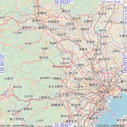
| Upper-left | 36.50281°, | 138.60132° |
| Center: | 35.93556°, | 139.30444° |
| Lower-right: | 35.36421°, | 140.00757° |
| Map W x H: | 126.6×126.6 km | = 78.7×78.7mi |
| max Lat: | 45.40944° ⇑34.2% North |
| Morohongō: | 35.93556° |
| min Lat: | ⇓65.8% South 24.34478° |
| min Long | Morohongō | max Long |
| 123° | 139.30444° | 145.575° |
| W 64.3%⇐ | ⇒35.7% E |
Elevation
Elevation of Morohongō is 125 m = 410 ft, and this is 40.4 m = 133 ft above average elevation for this country.
| Max E: |
1086 m = 3563 ft | 19.6% |
| Morohongō | 125 m 410 ft | |
| Avg. | 84.6 m = 278 ft | |
Min E: |
-2 m = -7 ft | 80.4% |
See also: Japan elevation on elevation.city.
Geographical zone
Morohongō is located in North temperate zone (between Tropic of Cancer and the Arctic Circle). Distance of this Northern Tropic circle is 1389.7 km =863.5 mi to South.| Distance of | km | miles | from Morohongō |
|---|---|---|---|
| North Pole | 6011.4 | 3735.3 | to North |
| Arctic Circle | 3405.5 | 2116.1 | to North |
| Tropic Cancer | 1389.7 | 863.5 | to South |
| Equator | 3995.7 | 2482.8 | to South |


Nearby cities:
15 places around Morohongō: (largest is in red/bold)
• Chichibu
21.4 km =13.3 mi,  286°
286°
• Fujimino
20.7 km =12.9 mi,  113°
113°
• Hamura
19.3 km =12 mi,  175°
175°
• Hannō
9.4 km =5.8 mi,  172°
172°
• Hidaka
5.6 km =3.5 mi, 111°
• Higashi-Matsuyama
14.8 km =9.2 mi,  42°
42°
• Iruma
14.3 km =8.9 mi,  156°
156°
• Kamifukuoka
20.1 km =12.5 mi, 110°
• Kawagoe
16.6 km =10.3 mi,  100°
100°
• Ogawa
13.6 km =8.5 mi,  345°
345°
• Sakado
8 km =5 mi,  72°
72°
• Sayama
13.4 km =8.3 mi,  133°
133°
• Tokorozawa
21.2 km =13.2 mi,  135°
135°
• Tsurugashima
9.3 km =5.8 mi, 72°
• Ōme
17.7 km =11 mi,  198°
198°
Sources, notices
• [Note1] Compared only with cities in Japan existing in our database
• [Src1] Map data: © OpenStreetMap contributors (CC-BY-SA)
• [Src2] Other city data from geonames.org with taken over terms of usage.
• [Src3] Geographical zone / Annual Mean Temperature by Robert A. Rohde @ Wikipedia
