Ōshū geodata
Ōshū (Iwate) is a seat of a second-order administrative division; located in Japan in Asia/Tokyo (GMT+9) time zone. In our database, there are 767 cities with bigger population. Compared to other cities in Japan, 91% of cities are located further ↓South; 94.1% of cities are located further ←West and 55.7% of cities have lower elevation than Ōshū. Note1


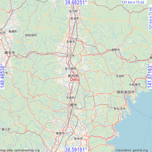
Ōshū GPS coordinates[2]
39° 8' 21.372" North, 141° 10' 6.6" East
| Map corner | latitude | longitude |
|---|---|---|
| Upper-left | 39.68251°, | 140.46538° |
| Center: | 39.13927°, | 141.1685° |
| Lower-right: | 38.59181°, | 141.87163° |
| Map W x H: | 121.3×121.3 km | = 75.4×75.4mi |
| max Lat: | 45.40944° ⇑9% North |
| Ōshū: | 39.13927° |
| min Lat: | ⇓91% South 24.34478° |
| min Long | Ōshū | max Long |
| 123° | 141.1685° | 145.575° |
| W 94.1%⇐ | ⇒5.9% E |
Elevation
Elevation of Ōshū is 36 m = 118 ft, and this is 48.6 m = 159 ft below average elevation for this country.
| Max E: |
1086 m = 3563 ft | 44.3% |
| Avg. | 84.6 m = 278 ft | |
| Ōshū | 36 m = 118 ft | |
Min E: |
-2 m = -7 ft | 55.7% |
See also: Japan elevation on elevation.city.
Geographical zone
Ōshū is located in North temperate zone (between Tropic of Cancer and the Arctic Circle). Distance of this Northern Tropic circle is 1746 km =1084.9 mi to South.| Distance of | km | miles | from Ōshū |
|---|---|---|---|
| North Pole | 5655.2 | 3514 | to North |
| Arctic Circle | 3049.3 | 1894.7 | to North |
| Tropic Cancer | 1746 | 1084.9 | to South |
| Equator | 4351.9 | 2704.1 | to South |


Nearby cities:
15 places around Ōshū: (largest is in red/bold)
• Hanamaki
27.5 km =17.1 mi,  350°
350°
• Ichinoseki
24.9 km =15.5 mi,  186°
186°
• Kamaishi
62.2 km =38.6 mi,  75°
75°
• Kesennuma
44.2 km =27.5 mi,  126°
126°
• Kitakami
16.6 km =10.3 mi,  344°
344°
• Kurihara
45.7 km =28.4 mi,  198°
198°
• Mizusawa
3.1 km =1.9 mi,  257°
257°
• Morioka
62.4 km =38.8 mi,  358°
358°
• Rikuzentakata
38.9 km =24.2 mi,  106°
106°
• Tome
47.9 km =29.8 mi,  181°
181°
• Tōno
37.1 km =23.1 mi,  57°
57°
• Yokote
56.8 km =35.3 mi,  290°
290°
• Yuzawa
57.7 km =35.9 mi,  273°
273°
• Ōfunato
47.9 km =29.8 mi,  99°
99°
• Ōsaki
63.5 km =39.5 mi, 195°
Sources, notices
• [Note1] Compared only with cities in Japan existing in our database
• [Src1] Map data: © OpenStreetMap contributors (CC-BY-SA)
• [Src2] Other city data from geonames.org with taken over terms of usage.
• [Src3] Geographical zone / Annual Mean Temperature by Robert A. Rohde @ Wikipedia
