Kamaishi geodata
Kamaishi (Iwate) is a seat of a second-order administrative division; located in Japan in Asia/Tokyo (GMT+9) time zone. With population of 43,107 people, there are 421 cities with bigger population in this country. Compared to other cities in Japan, 91.3% of cities are located further ↓South; 97.2% of cities are located further ←West and 53.2% of cities have higher elevation than Kamaishi. Note1


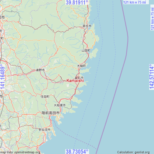
Kamaishi GPS coordinates[2]
39° 16' 36.984" North, 141° 52' 4.836" East
| Map corner | latitude | longitude |
|---|---|---|
| Upper-left | 39.81911°, | 141.16489° |
| Center: | 39.27694°, | 141.86801° |
| Lower-right: | 38.73054°, | 142.57114° |
| Map W x H: | 121×121 km | = 75.2×75.2mi |
| max Lat: | 45.40944° ⇑8.7% North |
| Kamaishi: | 39.27694° |
| min Lat: | ⇓91.3% South 24.34478° |
| min Long | Kamaishi | max Long |
| 123° | 141.86801° | 145.575° |
| W 97.2%⇐ | ⇒2.8% E |
Elevation
Elevation of Kamaishi is 25 m = 82 ft, and this is 59.6 m = 196 ft below average elevation for this country.
| Max E: |
1086 m = 3563 ft | 53.2% |
| Avg. | 84.6 m = 278 ft | |
| Kamaishi | 25 m = 82 ft | |
Min E: |
-2 m = -7 ft | 46.8% |
See also: Kamaishi elevation on elevation.city.
Geographical zone
Kamaishi is located in North temperate zone (between Tropic of Cancer and the Arctic Circle). Distance of this Northern Tropic circle is 1761.3 km =1094.4 mi to South.| Distance of | km | miles | from Kamaishi |
|---|---|---|---|
| North Pole | 5639.9 | 3504.5 | to North |
| Arctic Circle | 3034 | 1885.2 | to North |
| Tropic Cancer | 1761.3 | 1094.4 | to South |
| Equator | 4367.2 | 2713.7 | to South |


Nearby cities:
15 places around Kamaishi: (largest is in red/bold)
• Hanamaki
65.7 km =40.8 mi,  280°
280°
• Ichinoseki
75 km =46.6 mi,  237°
237°
• Kesennuma
48.7 km =30.3 mi,  210°
210°
• Kitakami
64.7 km =40.2 mi,  270°
270°
• Miyako
41.6 km =25.8 mi,  8°
8°
• Mizusawa
65.3 km =40.6 mi,  255°
255°
• Morioka
77.5 km =48.2 mi,  307°
307°
• Rikuzentakata
35.2 km =21.9 mi,  220°
220°
• Takizawa
85.9 km =53.4 mi, 312°
• Tome
88.2 km =54.8 mi, 224°
• Tōno
29.1 km =18.1 mi, 278°
• Yamada
22.2 km =13.8 mi,  18°
18°
• Ōfunato
26.3 km =16.3 mi, 209°
• Ōshū
62.2 km =38.6 mi, 255°
• Ōtsuchi
10.3 km =6.4 mi, 15°
Sources, notices
• [Note1] Compared only with cities in Japan existing in our database
• [Src1] Map data: © OpenStreetMap contributors (CC-BY-SA)
• [Src2] Other city data from geonames.org with taken over terms of usage.
• [Src3] Geographical zone / Annual Mean Temperature by Robert A. Rohde @ Wikipedia
