Yuzawa geodata
Yuzawa (Akita) is a seat of a second-order administrative division; located in Japan in Asia/Tokyo (GMT+9) time zone. With population of 33,536 people, there are 511 cities with bigger population in this country. Compared to other cities in Japan, 91.1% of cities are located further ↓South; 87.1% of cities are located further ←West and 76.1% of cities have lower elevation than Yuzawa. Note1


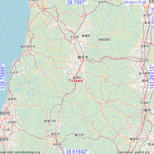
Yuzawa GPS coordinates[2]
39° 10' 0.012" North, 140° 30' 0" East
| Map corner | latitude | longitude |
|---|---|---|
| Upper-left | 39.7097°, | 139.79688° |
| Center: | 39.16667°, | 140.5° |
| Lower-right: | 38.61942°, | 141.20313° |
| Map W x H: | 121.2×121.2 km | = 75.3×75.3mi |
| max Lat: | 45.40944° ⇑8.9% North |
| Yuzawa: | 39.16667° |
| min Lat: | ⇓91.1% South 24.34478° |
| min Long | Yuzawa | max Long |
| 123° | 140.5° | 145.575° |
| W 87.1%⇐ | ⇒12.9% E |
Elevation
Elevation of Yuzawa is 100 m = 328 ft, and this is 15.4 m = 51 ft above average elevation for this country.
| Max E: |
1086 m = 3563 ft | 23.9% |
| Yuzawa | 100 m 328 ft | |
| Avg. | 84.6 m = 278 ft | |
Min E: |
-2 m = -7 ft | 76.1% |
See also: Japan elevation on elevation.city.
Geographical zone
Yuzawa is located in North temperate zone (between Tropic of Cancer and the Arctic Circle). Distance of this Northern Tropic circle is 1749 km =1086.8 mi to South.| Distance of | km | miles | from Yuzawa |
|---|---|---|---|
| North Pole | 5652.1 | 3512.1 | to North |
| Arctic Circle | 3046.2 | 1892.8 | to North |
| Tropic Cancer | 1749 | 1086.8 | to South |
| Equator | 4354.9 | 2706 | to South |


Nearby cities:
15 places around Yuzawa: (largest is in red/bold)
• Daisen
30.5 km =19 mi,  358°
358°
• Hanamaki
58.3 km =36.2 mi,  65°
65°
• Ichinoseki
61.4 km =38.2 mi,  116°
116°
• Kakunodatemachi
47.3 km =29.4 mi,  7°
7°
• Kitakami
54.7 km =34 mi,  76°
76°
• Mizusawa
54.7 km =34 mi,  93°
93°
• Nikaho
49.7 km =30.9 mi,  283°
283°
• Obanazawa
63.2 km =39.3 mi,  187°
187°
• Sakata
62.3 km =38.7 mi,  243°
243°
• Shinjō
48.5 km =30.1 mi,  200°
200°
• Yokote
17.3 km =10.7 mi, 14°
• Yurihonjō
45.4 km =28.2 mi,  303°
303°
• Yuza
52 km =32.3 mi,  251°
251°
• Ōmagari
31.5 km =19.6 mi, 357°
• Ōshū
57.7 km =35.9 mi, 93°
Sources, notices
• [Note1] Compared only with cities in Japan existing in our database
• [Src1] Map data: © OpenStreetMap contributors (CC-BY-SA)
• [Src2] Other city data from geonames.org with taken over terms of usage.
• [Src3] Geographical zone / Annual Mean Temperature by Robert A. Rohde @ Wikipedia
