Kesennuma geodata
Kesennuma (Miyagi) is a seat of a second-order administrative division; located in Japan in Asia/Tokyo (GMT+9) time zone. In our database, there are 767 cities with bigger population. Compared to other cities in Japan, 90.4% of cities are located further ↓South; 96.2% of cities are located further ←West and 66.8% of cities have higher elevation than Kesennuma. Note1


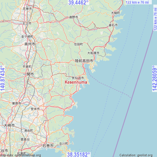
Kesennuma GPS coordinates[2]
38° 54' 4.032" North, 141° 34' 38.856" East
| Map corner | latitude | longitude |
|---|---|---|
| Upper-left | 39.4462°, | 140.87434° |
| Center: | 38.90112°, | 141.57746° |
| Lower-right: | 38.35182°, | 142.28059° |
| Map W x H: | 121.7×121.7 km | = 75.6×75.6mi |
| max Lat: | 45.40944° ⇑9.6% North |
| Kesennuma: | 38.90112° |
| min Lat: | ⇓90.4% South 24.34478° |
| min Long | Kesennuma | max Long |
| 123° | 141.57746° | 145.575° |
| W 96.2%⇐ | ⇒3.8% E |
Elevation
Elevation of Kesennuma is 14 m = 46 ft, and this is 70.6 m = 232 ft below average elevation for this country.
| Max E: |
1086 m = 3563 ft | 66.8% |
| Avg. | 84.6 m = 278 ft | |
| Kesennuma | 14 m = 46 ft | |
Min E: |
-2 m = -7 ft | 33.2% |
See also: Japan elevation on elevation.city.
Geographical zone
Kesennuma is located in North temperate zone (between Tropic of Cancer and the Arctic Circle). Distance of this Northern Tropic circle is 1719.5 km =1068.4 mi to South.| Distance of | km | miles | from Kesennuma |
|---|---|---|---|
| North Pole | 5681.7 | 3530.4 | to North |
| Arctic Circle | 3075.8 | 1911.2 | to North |
| Tropic Cancer | 1719.5 | 1068.4 | to South |
| Equator | 4325.4 | 2687.7 | to South |


Nearby cities:
15 places around Kesennuma: (largest is in red/bold)
• Ichinoseki
38.5 km =23.9 mi,  272°
272°
• Ishinomaki
59 km =36.7 mi,  204°
204°
• Kamaishi
48.7 km =30.3 mi,  30°
30°
• Kitakami
58.2 km =36.2 mi,  316°
316°
• Kogota
60.1 km =37.3 mi,  229°
229°
• Kurihara
52.8 km =32.8 mi,  251°
251°
• Mizusawa
46.2 km =28.7 mi,  303°
303°
• Onagawa Chō
51.8 km =32.2 mi,  192°
192°
• Rikuzentakata
15.3 km =9.5 mi,  7°
7°
• Tome
42.3 km =26.3 mi,  239°
239°
• Tōno
46.4 km =28.8 mi,  355°
355°
• Wakuya
55.2 km =34.3 mi,  224°
224°
• Ōfunato
22.5 km =14 mi, 32°
• Ōshū
44.2 km =27.5 mi,  306°
306°
• Ōtsuchi
58.8 km =36.5 mi, 28°
Sources, notices
• [Note1] Compared only with cities in Japan existing in our database
• [Src1] Map data: © OpenStreetMap contributors (CC-BY-SA)
• [Src2] Other city data from geonames.org with taken over terms of usage.
• [Src3] Geographical zone / Annual Mean Temperature by Robert A. Rohde @ Wikipedia
