Susono geodata
Susono (Shizuoka) is a seat of a second-order administrative division; located in Japan in Asia/Tokyo (GMT+9) time zone. In our database, there are 767 cities with bigger population. Compared to other cities in Japan, 54.5% of cities are located further ↑North; 59.3% of cities are located further ←West and 81.6% of cities have lower elevation than Susono. Note1


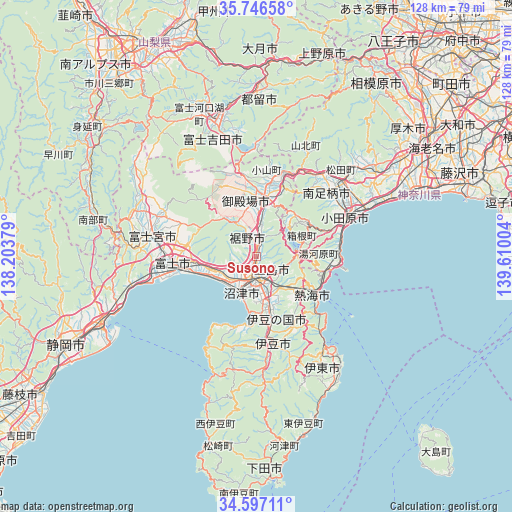
Susono GPS coordinates[2]
35° 10' 25.968" North, 138° 54' 24.876" East
| Map corner | latitude | longitude |
|---|---|---|
| Upper-left | 35.74658°, | 138.20379° |
| Center: | 35.17388°, | 138.90691° |
| Lower-right: | 34.59711°, | 139.61004° |
| Map W x H: | 127.8×127.8 km | = 79.4×79.4mi |
| max Lat: | 45.40944° ⇑54.5% North |
| Susono: | 35.17388° |
| min Lat: | ⇓45.5% South 24.34478° |
| min Long | Susono | max Long |
| 123° | 138.90691° | 145.575° |
| W 59.3%⇐ | ⇒40.7% E |
Elevation
Elevation of Susono is 133 m = 436 ft, and this is 48.4 m = 159 ft above average elevation for this country.
| Max E: |
1086 m = 3563 ft | 18.4% |
| Susono | 133 m 436 ft | |
| Avg. | 84.6 m = 278 ft | |
Min E: |
-2 m = -7 ft | 81.6% |
See also: Japan elevation on elevation.city.
Geographical zone
Susono is located in North temperate zone (between Tropic of Cancer and the Arctic Circle). Distance of this Northern Tropic circle is 1305 km =810.9 mi to South.| Distance of | km | miles | from Susono |
|---|---|---|---|
| North Pole | 6096.1 | 3787.9 | to North |
| Arctic Circle | 3490.2 | 2168.7 | to North |
| Tropic Cancer | 1305 | 810.9 | to South |
| Equator | 3911 | 2430.2 | to South |


Nearby cities:
15 places around Susono: (largest is in red/bold)
• Atami
16.4 km =10.2 mi,  125°
125°
• Fuji
20.3 km =12.6 mi,  267°
267°
• Fujinomiya
26.8 km =16.7 mi,  280°
280°
• Gotenba
16.4 km =10.2 mi,  11°
11°
• Hakone
11 km =6.8 mi,  80°
80°
• Heda
25.9 km =16.1 mi,  205°
205°
• Itō
28.1 km =17.5 mi,  145°
145°
• Izu
22.8 km =14.2 mi,  170°
170°
• Izunokuni
15.5 km =9.6 mi,  164°
164°
• Minamiashigara
24.5 km =15.2 mi,  48°
48°
• Mishima
6.4 km =4 mi, 172°
• Numazu
9 km =5.6 mi,  204°
204°
• Odawara
24.7 km =15.3 mi,  68°
68°
• Yamakita
26.3 km =16.3 mi,  36°
36°
• Yugawara
14.8 km =9.2 mi,  100°
100°
Sources, notices
• [Note1] Compared only with cities in Japan existing in our database
• [Src1] Map data: © OpenStreetMap contributors (CC-BY-SA)
• [Src2] Other city data from geonames.org with taken over terms of usage.
• [Src3] Geographical zone / Annual Mean Temperature by Robert A. Rohde @ Wikipedia
