Gotenba geodata
Gotenba (Shizuoka) is a seat of a second-order administrative division; located in Japan in Asia/Tokyo (GMT+9) time zone. With population of 83,794 people, there are 237 cities with bigger population in this country. Compared to other cities in Japan, 51.4% of cities are located further ↑North; 59.7% of cities are located further ←West and 96.4% of cities have lower elevation than Gotenba. Note1


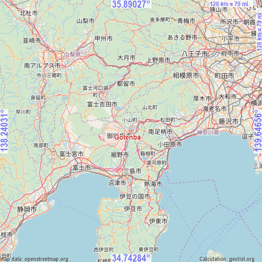
Gotenba GPS coordinates[2]
35° 19' 6.924" North, 138° 56' 36.348" East
| Map corner | latitude | longitude |
|---|---|---|
| Upper-left | 35.89027°, | 138.24031° |
| Center: | 35.31859°, | 138.94343° |
| Lower-right: | 34.74284°, | 139.64656° |
| Map W x H: | 127.6×127.6 km | = 79.3×79.3mi |
| max Lat: | 45.40944° ⇑51.4% North |
| Gotenba: | 35.31859° |
| min Lat: | ⇓48.6% South 24.34478° |
| min Long | Gotenba | max Long |
| 123° | 138.94343° | 145.575° |
| W 59.7%⇐ | ⇒40.3% E |
Elevation
Elevation of Gotenba is 446 m = 1463 ft, and this is 361.4 m = 1186 ft above average elevation for this country.
| Max E: |
1086 m = 3563 ft | 3.6% |
| Gotenba | 446 m 1463 ft | |
| Avg. | 84.6 m = 278 ft | |
Min E: |
-2 m = -7 ft | 96.4% |
See also: Gotenba elevation on elevation.city.
Geographical zone
Gotenba is located in North temperate zone (between Tropic of Cancer and the Arctic Circle). Distance of this Northern Tropic circle is 1321.1 km =820.9 mi to South.| Distance of | km | miles | from Gotenba |
|---|---|---|---|
| North Pole | 6080 | 3777.9 | to North |
| Arctic Circle | 3474.1 | 2158.7 | to North |
| Tropic Cancer | 1321.1 | 820.9 | to South |
| Equator | 3927.1 | 2440.2 | to South |


Nearby cities:
15 places around Gotenba: (largest is in red/bold)
• Atami
27.5 km =17.1 mi,  158°
158°
• Fuji
29 km =18 mi,  234°
234°
• Fuji-yoshida
22 km =13.7 mi,  327°
327°
• Fujiyoshida
19 km =11.8 mi,  315°
315°
• Hadano
26.1 km =16.2 mi,  77°
77°
• Hakone
16.2 km =10.1 mi,  152°
152°
• Minamiashigara
15.1 km =9.4 mi,  89°
89°
• Mishima
22.6 km =14 mi,  186°
186°
• Ninomiya
28.4 km =17.6 mi, 93°
• Numazu
25.3 km =15.7 mi,  196°
196°
• Odawara
20.8 km =12.9 mi,  109°
109°
• Susono
16.4 km =10.2 mi, 191°
• Tsuru
25.6 km =15.9 mi,  353°
353°
• Yamakita
13.3 km =8.3 mi,  68°
68°
• Yugawara
21.8 km =13.5 mi, 149°
Sources, notices
• [Note1] Compared only with cities in Japan existing in our database
• [Src1] Map data: © OpenStreetMap contributors (CC-BY-SA)
• [Src2] Other city data from geonames.org with taken over terms of usage.
• [Src3] Geographical zone / Annual Mean Temperature by Robert A. Rohde @ Wikipedia
