Fujinomiya geodata
Fujinomiya (Shizuoka) is a seat of a second-order administrative division; located in Japan in Asia/Tokyo (GMT+9) time zone. With population of 121,515 people, there are 174 cities with bigger population in this country. Compared to other cities in Japan, 53.9% of cities are located further ↑North; 57.2% of cities are located further ←West and 79.2% of cities have lower elevation than Fujinomiya. Note1


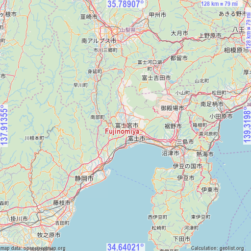
Fujinomiya GPS coordinates[2]
35° 13' 0.012" North, 138° 37' 0.012" East
| Map corner | latitude | longitude |
|---|---|---|
| Upper-left | 35.78907°, | 137.91355° |
| Center: | 35.21667°, | 138.61667° |
| Lower-right: | 34.64021°, | 139.3198° |
| Map W x H: | 127.7×127.7 km | = 79.3×79.3mi |
| max Lat: | 45.40944° ⇑53.9% North |
| Fujinomiya: | 35.21667° |
| min Lat: | ⇓46.1% South 24.34478° |
| min Long | Fujinomiya | max Long |
| 123° | 138.61667° | 145.575° |
| W 57.2%⇐ | ⇒42.8% E |
Elevation
Elevation of Fujinomiya is 116 m = 381 ft, and this is 31.4 m = 103 ft above average elevation for this country.
| Max E: |
1086 m = 3563 ft | 20.8% |
| Fujinomiya | 116 m 381 ft | |
| Avg. | 84.6 m = 278 ft | |
Min E: |
-2 m = -7 ft | 79.2% |
See also: Fujinomiya elevation on elevation.city.
Geographical zone
Fujinomiya is located in North temperate zone (between Tropic of Cancer and the Arctic Circle). Distance of this Northern Tropic circle is 1309.8 km =813.9 mi to South.| Distance of | km | miles | from Fujinomiya |
|---|---|---|---|
| North Pole | 6091.3 | 3785 | to North |
| Arctic Circle | 3485.4 | 2165.7 | to North |
| Tropic Cancer | 1309.8 | 813.9 | to South |
| Equator | 3915.7 | 2433.1 | to South |


Nearby cities:
15 places around Fujinomiya: (largest is in red/bold)
• Atami
42.2 km =26.2 mi,  109°
109°
• Fuji
8.2 km =5.1 mi,  132°
132°
• Fuji-yoshida
34.6 km =21.5 mi,  30°
30°
• Fujikawaguchiko
31 km =19.3 mi,  12°
12°
• Fujiyoshida
29.7 km =18.5 mi, 33°
• Gotenba
31.8 km =19.8 mi,  69°
69°
• Hakone
37.4 km =23.2 mi,  94°
94°
• Heda
32.1 km =19.9 mi,  151°
151°
• Izu
40.5 km =25.2 mi, 132°
• Izunokuni
36.3 km =22.6 mi,  122°
122°
• Mishima
29.4 km =18.3 mi, 112°
• Numazu
26.2 km =16.3 mi, 119°
• Shizuoka
33.5 km =20.8 mi,  219°
219°
• Susono
26.8 km =16.7 mi,  100°
100°
• Yugawara
41.6 km =25.8 mi, 100°
Sources, notices
• [Note1] Compared only with cities in Japan existing in our database
• [Src1] Map data: © OpenStreetMap contributors (CC-BY-SA)
• [Src2] Other city data from geonames.org with taken over terms of usage.
• [Src3] Geographical zone / Annual Mean Temperature by Robert A. Rohde @ Wikipedia
