Kulundu geodata
Kulundu (Batken) is a seat of a third-order administrative division; located in Kyrgyzstan in Asia/Bishkek (GMT+6) time zone. In our database, there are 37 cities with bigger population. Compared to other cities in Kyrgyzstan, 76.2% of cities are located further ↑North; 95.2% of cities are located further →East and 96.4% of cities have higher elevation than Kulundu. Note1


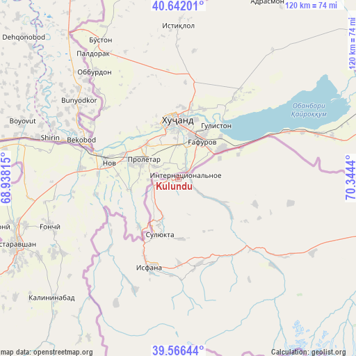
Kulundu GPS coordinates[2]
40° 6' 22.86" North, 69° 38' 28.572" East
| Map corner | latitude | longitude |
|---|---|---|
| Upper-left | 40.64201°, | 68.93815° |
| Center: | 40.10635°, | 69.64127° |
| Lower-right: | 39.56644°, | 70.3444° |
| Map W x H: | 119.6×119.6 km | = 74.3×74.3mi |
| max Lat: | 42.89106° ⇑76.2% North |
| Kulundu: | 40.10635° |
| min Lat: | ⇓23.8% South 39.55274° |
| min Long | Kulundu | max Long |
| 69.3716° | 69.64127° | 78.52702° |
| W 4.8%⇐ | ⇒95.2% E |
Elevation
Elevation of Kulundu is 642 m = 2106 ft, and this is 559.4 m = 1835 ft below average elevation for this country.
| Max E: |
2638 m = 8655 ft | 96.4% |
| Avg. | 1201.4 m = 3942 ft | |
| Kulundu | 642 m = 2106 ft | |
Min E: |
504 m = 1654 ft | 3.6% |
See also: Kyrgyzstan elevation on elevation.city.
Geographical zone
Kulundu is located in North temperate zone (between Tropic of Cancer and the Arctic Circle). Distance of this Northern Tropic circle is 1853.5 km =1151.7 mi to South.| Distance of | km | miles | from Kulundu |
|---|---|---|---|
| North Pole | 5547.7 | 3447.2 | to North |
| Arctic Circle | 2941.8 | 1827.9 | to North |
| Tropic Cancer | 1853.5 | 1151.7 | to South |
| Equator | 4459.4 | 2770.9 | to South |


Nearby cities:
15 places around Kulundu: (largest is in red/bold)
• Ak-Say
79.3 km =49.3 mi,  108°
108°
• Ak-Suu
32.6 km =20.3 mi,  224°
224°
• Ak-Tatyr
73.6 km =45.7 mi,  102°
102°
• Andarak
40.5 km =25.2 mi,  201°
201°
• Batken
100.3 km =62.3 mi,  92°
92°
• Beshkent
17.3 km =10.7 mi,  119°
119°
• Boz-Adyr
122.5 km =76.1 mi, 95°
• Chek
102.5 km =63.7 mi, 89°
• Isfana
31.3 km =19.4 mi, 198°
• Kara-Bak
100.4 km =62.4 mi, 86°
• Katran
43.1 km =26.8 mi,  132°
132°
• Korgon
34.8 km =21.6 mi, 133°
• Samarkandyk
77.9 km =48.4 mi, 98°
• Suluktu
19.9 km =12.4 mi, 198°
• Toguz-Bulak
29.9 km =18.6 mi,  168°
168°
Sources, notices
• [Note1] Compared only with cities in Kyrgyzstan existing in our database
• [Src1] Map data: © OpenStreetMap contributors (CC-BY-SA)
• [Src2] Other city data from geonames.org with taken over terms of usage.
• [Src3] Geographical zone / Annual Mean Temperature by Robert A. Rohde @ Wikipedia
