Svay Rieng geodata
Svay Rieng is a seat of a first-order administrative division; located in Cambodia in Asia/Phnom_Penh (GMT+7) time zone. With population of 23,956 people, there are 18 cities with bigger population in this country. Compared to other cities in Cambodia, 86.4% of cities are located further ↑North; 84.8% of cities are located further ←West and 80.3% of cities have higher elevation than Svay Rieng. Note1


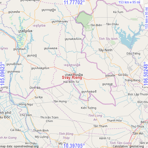
Svay Rieng GPS coordinates[2]
11° 5' 16.26" North, 105° 47' 57.66" East
| Map corner | latitude | longitude |
|---|---|---|
| Upper-left | 11.77702°, | 105.09623° |
| Center: | 11.08785°, | 105.79935° |
| Lower-right: | 10.39705°, | 106.50248° |
| Map W x H: | 153.4×153.4 km | = 95.3×95.3mi |
| max Lat: | 14.23223° ⇑86.4% North |
| Svay Rieng: | 11.08785° |
| min Lat: | ⇓13.6% South 10.48291° |
| min Long | Svay Rieng | max Long |
| 102.37574° | 105.79935° | 107.42393° |
| W 84.8%⇐ | ⇒15.2% E |
Elevation
Elevation of Svay Rieng is 12 m = 39 ft, and this is 40 m = 131 ft below average elevation for this country.
| Max E: |
678 m = 2224 ft | 80.3% |
| Avg. | 52 m = 171 ft | |
| Svay Rieng | 12 m = 39 ft | |
Min E: |
4 m = 13 ft | 19.7% |
See also: Cambodia elevation on elevation.city.
Geographical zone
Svay Rieng is located in North Torrid zone (between Equator and Tropic of Cancer). Distance of Equator is 1232.9 km =766.1 mi to South.| Distance of | km | miles | from Svay Rieng |
|---|---|---|---|
| North Pole | 8774.2 | 5452 | to North |
| Arctic Circle | 6168.3 | 3832.8 | to North |
| Tropic Cancer | 1373.1 | 853.2 | to North |
| Equator | 1232.9 | 766.1 | to South |


Nearby cities:
15 places around Svay Rieng: (largest is in red/bold)
• Bourei Cholsar
89.8 km =55.8 mi,  251°
251°
• Chantrea
37.3 km =23.2 mi,  107°
107°
• Kampong Leav
67.1 km =41.7 mi,  312°
312°
• Kampong Trabaek
35.1 km =21.8 mi,  280°
280°
• Koah Thum
81.1 km =50.4 mi,  272°
272°
• Leuk Daek
63 km =39.1 mi, 278°
• Me Sang
38.4 km =23.9 mi, 313°
• Peam Chor
63.1 km =39.2 mi, 271°
• Peam Ro
61.4 km =38.2 mi,  293°
293°
• Preah Sdach
45.3 km =28.1 mi, 271°
• Prey Veaeng
67.8 km =42.1 mi,  322°
322°
• Prey Veng
68.1 km =42.3 mi, 310°
• Rumduol
8.3 km =5.2 mi,  17°
17°
• Sithor Kandal
88.7 km =55.1 mi,  329°
329°
• Svay Teab
10.1 km =6.3 mi, 111°
Sources, notices
• [Note1] Compared only with cities in Cambodia existing in our database
• [Src1] Map data: © OpenStreetMap contributors (CC-BY-SA)
• [Src2] Other city data from geonames.org with taken over terms of usage.
• [Src3] Geographical zone / Annual Mean Temperature by Robert A. Rohde @ Wikipedia
