Chhloung geodata
Chhloung (Kratie) is a seat of a second-order administrative division; located in Cambodia in Asia/Phnom_Penh (GMT+7) time zone. In our database, there are 29 cities with bigger population. Compared to other cities in Cambodia, 50% of cities are located further ↓South; 87.9% of cities are located further ←West and 64.4% of cities have lower elevation than Chhloung. Note1


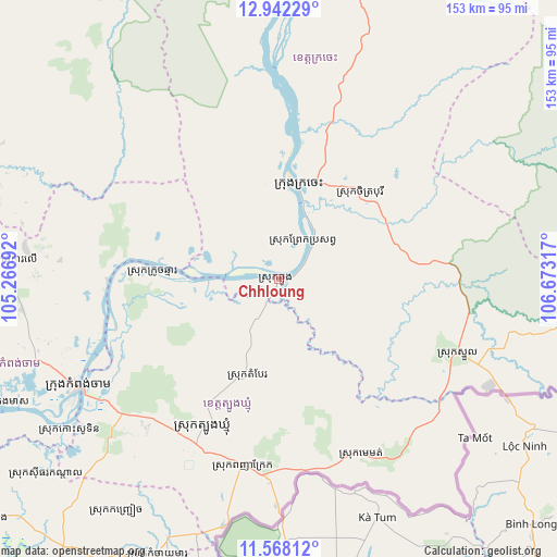
Chhloung GPS coordinates[2]
12° 15' 21.96" North, 105° 58' 12.144" East
| Map corner | latitude | longitude |
|---|---|---|
| Upper-left | 12.94229°, | 105.26692° |
| Center: | 12.2561°, | 105.97004° |
| Lower-right: | 11.56812°, | 106.67317° |
| Map W x H: | 152.8×152.8 km | = 94.9×94.9mi |
| max Lat: | 14.23223° ⇑50% North |
| Chhloung: | 12.2561° |
| min Lat: | ⇓50% South 10.48291° |
| min Long | Chhloung | max Long |
| 102.37574° | 105.97004° | 107.42393° |
| W 87.9%⇐ | ⇒12.1% E |
Elevation
Elevation of Chhloung is 29 m = 95 ft, and this is 23 m = 75 ft below average elevation for this country.
| Max E: |
678 m = 2224 ft | 35.6% |
| Avg. | 52 m = 171 ft | |
| Chhloung | 29 m = 95 ft | |
Min E: |
4 m = 13 ft | 64.4% |
See also: Cambodia elevation on elevation.city.
Geographical zone
Chhloung is located in North Torrid zone (between Equator and Tropic of Cancer). Distance of this Northern Tropic circle is 1243.2 km =772.5 mi to North.| Distance of | km | miles | from Chhloung |
|---|---|---|---|
| North Pole | 8644.3 | 5371.3 | to North |
| Arctic Circle | 6038.4 | 3752.1 | to North |
| Tropic Cancer | 1243.2 | 772.5 | to North |
| Equator | 1362.8 | 846.8 | to South |


Nearby cities:
15 places around Chhloung: (largest is in red/bold)
• Baray
98.4 km =61.1 mi,  278°
278°
• Chamkar Leu
75 km =46.6 mi,  274°
274°
• Cheung Prey
99.8 km =62 mi,  257°
257°
• Kaev Seima
99.2 km =61.6 mi,  94°
94°
• Kampong Cham
62.3 km =38.7 mi,  242°
242°
• Kampong Leav
108.9 km =67.7 mi,  218°
218°
• Kang Meas
83.1 km =51.6 mi,  245°
245°
• Kaoh Soutin
71.9 km =44.7 mi, 235°
• Kratié
26.3 km =16.3 mi,  11°
11°
• Preaek Prasab
13 km =8.1 mi,  33°
33°
• Prey Chhor
80.5 km =50 mi, 254°
• Prey Veaeng
96.8 km =60.1 mi, 218°
• Sithor Kandal
83.5 km =51.9 mi,  229°
229°
• Stueng Trang
47.2 km =29.3 mi, 269°
• Suong
51.1 km =31.8 mi, 221°
Sources, notices
• [Note1] Compared only with cities in Cambodia existing in our database
• [Src1] Map data: © OpenStreetMap contributors (CC-BY-SA)
• [Src2] Other city data from geonames.org with taken over terms of usage.
• [Src3] Geographical zone / Annual Mean Temperature by Robert A. Rohde @ Wikipedia
