Kratié geodata
Kratié (Kratie) is a seat of a first-order administrative division; located in Cambodia in Asia/Phnom_Penh (GMT+7) time zone. With population of 19,975 people, there are 21 cities with bigger population in this country. Compared to other cities in Cambodia, 56.8% of cities are located further ↓South; 88.6% of cities are located further ←West and 60.6% of cities have lower elevation than Kratié. Note1


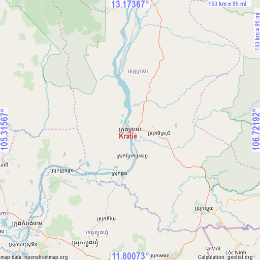
Kratié GPS coordinates[2]
12° 29' 17.196" North, 106° 1' 7.644" East
| Map corner | latitude | longitude |
|---|---|---|
| Upper-left | 13.17367°, | 105.31567° |
| Center: | 12.48811°, | 106.01879° |
| Lower-right: | 11.80073°, | 106.72192° |
| Map W x H: | 152.7×152.7 km | = 94.9×94.9mi |
| max Lat: | 14.23223° ⇑43.2% North |
| Kratié: | 12.48811° |
| min Lat: | ⇓56.8% South 10.48291° |
| min Long | Kratié | max Long |
| 102.37574° | 106.01879° | 107.42393° |
| W 88.6%⇐ | ⇒11.4% E |
Elevation
Elevation of Kratié is 27 m = 89 ft, and this is 25 m = 82 ft below average elevation for this country.
| Max E: |
678 m = 2224 ft | 39.4% |
| Avg. | 52 m = 171 ft | |
| Kratié | 27 m = 89 ft | |
Min E: |
4 m = 13 ft | 60.6% |
See also: Cambodia elevation on elevation.city.
Geographical zone
Kratié is located in North Torrid zone (between Equator and Tropic of Cancer). Distance of this Northern Tropic circle is 1217.4 km =756.5 mi to North.| Distance of | km | miles | from Kratié |
|---|---|---|---|
| North Pole | 8618.5 | 5355.3 | to North |
| Arctic Circle | 6012.6 | 3736.1 | to North |
| Tropic Cancer | 1217.4 | 756.5 | to North |
| Equator | 1388.5 | 862.8 | to South |


Nearby cities:
15 places around Kratié: (largest is in red/bold)
• Baray
103 km =64 mi,  264°
264°
• Chamkar Leu
82.5 km =51.3 mi, 255°
• Cheung Prey
113.2 km =70.3 mi,  244°
244°
• Chhloung
26.3 km =16.3 mi,  191°
191°
• Kaev Seima
99.4 km =61.8 mi,  109°
109°
• Kampong Cham
81.6 km =50.7 mi,  227°
227°
• Kang Meas
100.8 km =62.6 mi, 233°
• Kaoh Soutin
92.8 km =57.7 mi,  223°
223°
• Preaek Prasab
15.1 km =9.4 mi,  173°
173°
• Prey Chhor
95.6 km =59.4 mi, 239°
• Sandan
107.6 km =66.9 mi,  309°
309°
• Sithor Kandal
105.4 km =65.5 mi, 220°
• Stueng Trang
58.5 km =36.4 mi, 243°
• Stung Treng
115.5 km =71.8 mi,  357°
357°
• Suong
75.1 km =46.7 mi,  211°
211°
Sources, notices
• [Note1] Compared only with cities in Cambodia existing in our database
• [Src1] Map data: © OpenStreetMap contributors (CC-BY-SA)
• [Src2] Other city data from geonames.org with taken over terms of usage.
• [Src3] Geographical zone / Annual Mean Temperature by Robert A. Rohde @ Wikipedia
