Bak Khlang geodata
Bak Khlang (Koh Kong) is a seat of a third-order administrative division; located in Cambodia in Asia/Phnom_Penh (GMT+7) time zone. In our database, there are 29 cities with bigger population. Compared to other cities in Cambodia, 67.4% of cities are located further ↑North; 92.4% of cities are located further →East and 100% of cities have higher elevation than Bak Khlang. Note1


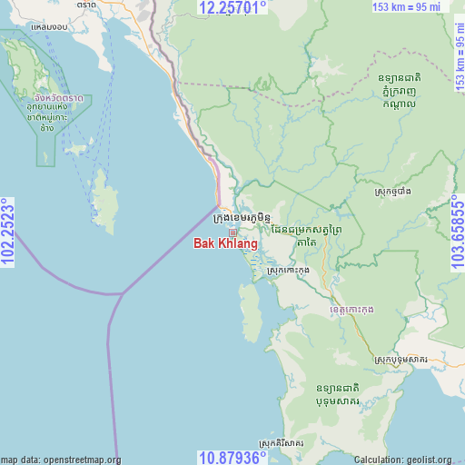
Bak Khlang GPS coordinates[2]
11° 34' 8.508" North, 102° 57' 19.512" East
| Map corner | latitude | longitude |
|---|---|---|
| Upper-left | 12.25701°, | 102.2523° |
| Center: | 11.56903°, | 102.95542° |
| Lower-right: | 10.87936°, | 103.65855° |
| Map W x H: | 153.2×153.2 km | = 95.2×95.2mi |
| max Lat: | 14.23223° ⇑67.4% North |
| Bak Khlang: | 11.56903° |
| min Lat: | ⇓32.6% South 10.48291° |
| min Long | Bak Khlang | max Long |
| 102.37574° | 102.95542° | 107.42393° |
| W 7.6%⇐ | ⇒92.4% E |
Elevation
Elevation of Bak Khlang is 4 m = 13 ft, and this is 48 m = 157 ft below average elevation for this country.
| Max E: |
678 m = 2224 ft | 100% |
| Avg. | 52 m = 171 ft | |
| Bak Khlang | 4 m = 13 ft | |
Min E: |
4 m = 13 ft | 0% |
See also: Cambodia elevation on elevation.city.
Geographical zone
Bak Khlang is located in North Torrid zone (between Equator and Tropic of Cancer). Distance of Equator is 1286.4 km =799.3 mi to South.| Distance of | km | miles | from Bak Khlang |
|---|---|---|---|
| North Pole | 8720.7 | 5418.8 | to North |
| Arctic Circle | 6114.8 | 3799.6 | to North |
| Tropic Cancer | 1319.6 | 820 | to North |
| Equator | 1286.4 | 799.3 | to South |


Nearby cities:
15 places around Bak Khlang: (largest is in red/bold)
• Aoral
128.6 km =79.9 mi,  84°
84°
• Botum Sakor
70.4 km =43.7 mi,  127°
127°
• Kampong Seila
115.9 km =72 mi,  117°
117°
• Koh Kong
6 km =3.7 mi,  30°
30°
• Mittakpheap
122.2 km =75.9 mi,  149°
149°
• Mondul Seima
6.2 km =3.9 mi,  354°
354°
• Phnum Kravanh
124.1 km =77.1 mi,  45°
45°
• Prey Nob
134.4 km =83.5 mi,  135°
135°
• Samlout
117 km =72.7 mi, 354°
• Sihanoukville
123.7 km =76.9 mi, 149°
• Smach Mean Chey
9.1 km =5.7 mi,  105°
105°
• Smach Meanchey
5.3 km =3.3 mi,  42°
42°
• Srae Ambel
100.2 km =62.3 mi, 119°
• Thma Bang
62.9 km =39.1 mi, 83°
• Veal Veaeng
83.4 km =51.8 mi,  11°
11°
Sources, notices
• [Note1] Compared only with cities in Cambodia existing in our database
• [Src1] Map data: © OpenStreetMap contributors (CC-BY-SA)
• [Src2] Other city data from geonames.org with taken over terms of usage.
• [Src3] Geographical zone / Annual Mean Temperature by Robert A. Rohde @ Wikipedia
