Smach Meanchey geodata
Smach Meanchey (Koh Kong) is a seat of a second-order administrative division; located in Cambodia in Asia/Phnom_Penh (GMT+7) time zone. In our database, there are 29 cities with bigger population. Compared to other cities in Cambodia, 65.9% of cities are located further ↑North; 89.4% of cities are located further →East and 97.7% of cities have higher elevation than Smach Meanchey. Note1


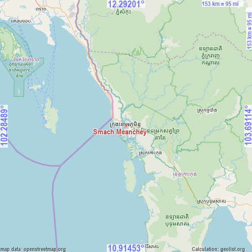
Smach Meanchey GPS coordinates[2]
11° 36' 14.832" North, 102° 59' 16.836" East
| Map corner | latitude | longitude |
|---|---|---|
| Upper-left | 12.29201°, | 102.28489° |
| Center: | 11.60412°, | 102.98801° |
| Lower-right: | 10.91453°, | 103.69114° |
| Map W x H: | 153.2×153.2 km | = 95.2×95.2mi |
| max Lat: | 14.23223° ⇑65.9% North |
| Smach Meanchey: | 11.60412° |
| min Lat: | ⇓34.1% South 10.48291° |
| min Long | Smach Meanchey | max Long |
| 102.37574° | 102.98801° | 107.42393° |
| W 10.6%⇐ | ⇒89.4% E |
Elevation
Elevation of Smach Meanchey is 6 m = 20 ft, and this is 46 m = 151 ft below average elevation for this country.
| Max E: |
678 m = 2224 ft | 97.7% |
| Avg. | 52 m = 171 ft | |
| Smach Meanchey | 6 m = 20 ft | |
Min E: |
4 m = 13 ft | 2.3% |
See also: Cambodia elevation on elevation.city.
Geographical zone
Smach Meanchey is located in North Torrid zone (between Equator and Tropic of Cancer). Distance of Equator is 1290.3 km =801.8 mi to South.| Distance of | km | miles | from Smach Meanchey |
|---|---|---|---|
| North Pole | 8716.8 | 5416.4 | to North |
| Arctic Circle | 6110.9 | 3797.1 | to North |
| Tropic Cancer | 1315.7 | 817.5 | to North |
| Equator | 1290.3 | 801.8 | to South |


Nearby cities:
15 places around Smach Meanchey: (largest is in red/bold)
• Aoral
124.7 km =77.5 mi,  85°
85°
• Bak Khlang
5.3 km =3.3 mi,  222°
222°
• Botum Sakor
70.2 km =43.6 mi,  131°
131°
• Kampong Seila
114.7 km =71.3 mi,  119°
119°
• Koas Krala
131.3 km =81.6 mi,  12°
12°
• Koh Kong
1.3 km =0.8 mi,  339°
339°
• Mittakpheap
123.8 km =76.9 mi,  151°
151°
• Mondul Seima
4.7 km =2.9 mi,  298°
298°
• Phnum Kravanh
118.8 km =73.8 mi,  45°
45°
• Samlout
113.5 km =70.5 mi,  352°
352°
• Sihanoukville
125.4 km =77.9 mi, 151°
• Smach Mean Chey
8.2 km =5.1 mi,  140°
140°
• Srae Ambel
99.2 km =61.6 mi, 122°
• Thma Bang
59 km =36.7 mi, 87°
• Veal Veaeng
78.9 km =49 mi, 9°
Sources, notices
• [Note1] Compared only with cities in Cambodia existing in our database
• [Src1] Map data: © OpenStreetMap contributors (CC-BY-SA)
• [Src2] Other city data from geonames.org with taken over terms of usage.
• [Src3] Geographical zone / Annual Mean Temperature by Robert A. Rohde @ Wikipedia
