Moutsamoudou geodata
Moutsamoudou (Anjouan) is a seat of a first-order administrative division; located in Comoros in Indian/Comoro (GMT+3) time zone. With population of 23,594 people, there is 1 city with bigger population in this country. Compared to other cities in Comoros, 56.6% of cities are located further ↑North; 76.1% of cities are located further ←West and 70.8% of cities have higher elevation than Moutsamoudou. Note1


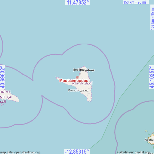
Moutsamoudou GPS coordinates[2]
12° 10' 0.192" South, 44° 23' 57.984" East
| Map corner | latitude | longitude |
|---|---|---|
| Upper-left | -11.47852°, | 43.69632° |
| Center: | -12.16672°, | 44.39944° |
| Lower-right: | -12.85315°, | 45.10257° |
| Map W x H: | 152.8×152.8 km | = 94.9×94.9mi |
| max Lat: | -11.38472° ⇑56.6% North |
| Moutsamoudou: | -12.16672° |
| min Lat: | ⇓43.4% South -12.37306° |
| min Long | Moutsamoudou | max Long |
| 43.2525° | 44.39944° | 44.53194° |
| W 76.1%⇐ | ⇒23.9% E |
Elevation
Elevation of Moutsamoudou is 61 m = 200 ft, and this is 135.1 m = 443 ft below average elevation for this country.
| Max E: |
924 m = 3031 ft | 70.8% |
| Avg. | 196.1 m = 643 ft | |
| Moutsamoudou | 61 m = 200 ft | |
Min E: |
1 m = 3 ft | 29.2% |
See also: Comoros elevation on elevation.city.
Geographical zone
Moutsamoudou is located in South Torrid zone (between Equator and Tropic of Capricorn). Distance of this Southern Tropic circle is 1253.1 km =778.6 mi to South.| Distance of | km | miles | from Moutsamoudou |
|---|---|---|---|
| Equator | 1352.8 | 840.6 | to North |
| Tropic Capricorn | 1253.1 | 778.6 | to South |
| Antarctic Circle | 6048.4 | 3758.3 | to South |
| South Pole | 8654.2 | 5377.5 | to South |


Nearby cities:
15 places around Moutsamoudou: (largest is in red/bold)
• Barakani
4.6 km =2.9 mi,  46°
46°
• Chandra
7.8 km =4.8 mi,  113°
113°
• Chironkamba
5.8 km =3.6 mi,  242°
242°
• Chitrouni
7.3 km =4.5 mi,  252°
252°
• Dziani
9.3 km =5.8 mi,  101°
101°
• Koki
4.6 km =2.9 mi, 96°
• Lingoni
10.1 km =6.3 mi,  168°
168°
• Mirontsi
1.5 km =0.9 mi,  39°
39°
• Mjimandra
4.2 km =2.6 mi,  228°
228°
• Ouani
4.4 km =2.7 mi, 38°
• Pajé
1.3 km =0.8 mi, 254°
• Patsi
4.3 km =2.7 mi,  73°
73°
• Tsimbeo
8.3 km =5.2 mi,  121°
121°
• Vassy
9.5 km =5.9 mi,  220°
220°
• Vouani
9 km =5.6 mi,  197°
197°
Sources, notices
• [Note1] Compared only with cities in Comoros existing in our database
• [Src1] Map data: © OpenStreetMap contributors (CC-BY-SA)
• [Src2] Other city data from geonames.org with taken over terms of usage.
• [Src3] Geographical zone / Annual Mean Temperature by Robert A. Rohde @ Wikipedia
