Koua geodata
Koua (Grande Comore) is a populated place; located in Comoros in Indian/Comoro (GMT+3) time zone. With population of 1,391 people, there are 71 cities with bigger population in this country. Compared to other cities in Comoros, 95.6% of cities are located further ↓South; 85.8% of cities are located further →East and 66.4% of cities have higher elevation than Koua. Note1


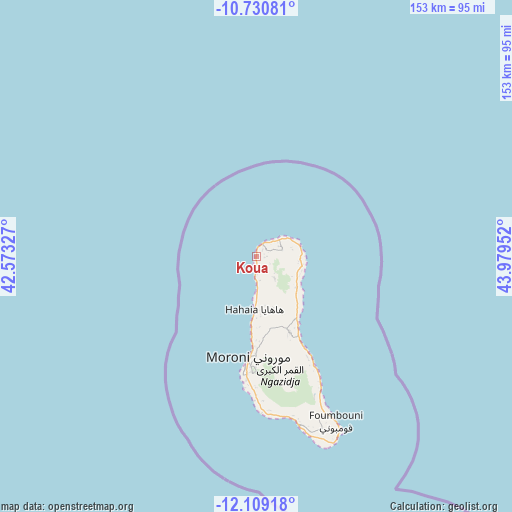
Koua GPS coordinates[2]
11° 25' 14.988" South, 43° 16' 35.004" East
| Map corner | latitude | longitude |
|---|---|---|
| Upper-left | -10.73081°, | 42.57327° |
| Center: | -11.42083°, | 43.27639° |
| Lower-right: | -12.10918°, | 43.97952° |
| Map W x H: | 153.3×153.3 km | = 95.3×95.3mi |
| max Lat: | -11.38472° ⇑4.4% North |
| Koua: | -11.42083° |
| min Lat: | ⇓95.6% South -12.37306° |
| min Long | Koua | max Long |
| 43.2525° | 43.27639° | 44.53194° |
| W 14.2%⇐ | ⇒85.8% E |
Elevation
Elevation of Koua is 80 m = 262 ft, and this is 116.1 m = 381 ft below average elevation for this country.
| Max E: |
924 m = 3031 ft | 66.4% |
| Avg. | 196.1 m = 643 ft | |
| Koua | 80 m = 262 ft | |
Min E: |
1 m = 3 ft | 33.6% |
See also: Comoros elevation on elevation.city.
Geographical zone
Koua is located in South Torrid zone (between Equator and Tropic of Capricorn). Distance of Equator is 1269.9 km =789.1 mi to North.| Distance of | km | miles | from Koua |
|---|---|---|---|
| Equator | 1269.9 | 789.1 | to North |
| Tropic Capricorn | 1336 | 830.2 | to South |
| Antarctic Circle | 6131.3 | 3809.8 | to South |
| South Pole | 8737.2 | 5429 | to South |


Nearby cities:
15 places around Koua: (largest is in red/bold)
• Bambadjani
12.7 km =7.9 mi,  120°
120°
• Batou
12.4 km =7.7 mi,  134°
134°
• Bouni
14.2 km =8.8 mi, 121°
• Chezani
13.1 km =8.1 mi,  95°
95°
• Douniani
1.4 km =0.9 mi,  91°
91°
• Hantsindzi
14.7 km =9.1 mi, 94°
• Itsandzéni
13.1 km =8.1 mi, 116°
• Ivouani
13.3 km =8.3 mi,  75°
75°
• Mandza
2.1 km =1.3 mi, 81°
• Mbéni
14.2 km =8.8 mi, 129°
• Milévani
14.6 km =9.1 mi,  174°
174°
• Mitsamiouli
4.1 km =2.5 mi,  12°
12°
• Ntsaouéni
5.2 km =3.2 mi,  196°
196°
• Ouellah
6.9 km =4.3 mi,  60°
60°
• Ouhozi
1.9 km =1.2 mi,  19°
19°
Sources, notices
• [Note1] Compared only with cities in Comoros existing in our database
• [Src1] Map data: © OpenStreetMap contributors (CC-BY-SA)
• [Src2] Other city data from geonames.org with taken over terms of usage.
• [Src3] Geographical zone / Annual Mean Temperature by Robert A. Rohde @ Wikipedia
