Bambadjani geodata
Bambadjani (Grande Comore) is a populated place; located in Comoros in Indian/Comoro (GMT+3) time zone. With population of 1,355 people, there are 74 cities with bigger population in this country. Compared to other cities in Comoros, 90.3% of cities are located further ↓South; 67.3% of cities are located further →East and 94.7% of cities have lower elevation than Bambadjani. Note1


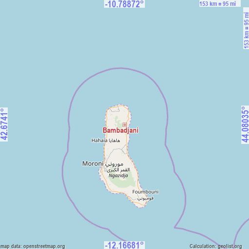
Bambadjani GPS coordinates[2]
11° 28' 42.996" South, 43° 22' 37.992" East
| Map corner | latitude | longitude |
|---|---|---|
| Upper-left | -10.78872°, | 42.6741° |
| Center: | -11.47861°, | 43.37722° |
| Lower-right: | -12.16681°, | 44.08035° |
| Map W x H: | 153.2×153.2 km | = 95.2×95.2mi |
| max Lat: | -11.38472° ⇑9.7% North |
| Bambadjani: | -11.47861° |
| min Lat: | ⇓90.3% South -12.37306° |
| min Long | Bambadjani | max Long |
| 43.2525° | 43.37722° | 44.53194° |
| W 32.7%⇐ | ⇒67.3% E |
Elevation
Elevation of Bambadjani is 577 m = 1893 ft, and this is 380.9 m = 1250 ft above average elevation for this country.
| Max E: |
924 m = 3031 ft | 5.3% |
| Bambadjani | 577 m 1893 ft | |
| Avg. | 196.1 m = 643 ft | |
Min E: |
1 m = 3 ft | 94.7% |
See also: Comoros elevation on elevation.city.
Geographical zone
Bambadjani is located in South Torrid zone (between Equator and Tropic of Capricorn). Distance of Equator is 1276.3 km =793.1 mi to North.| Distance of | km | miles | from Bambadjani |
|---|---|---|---|
| Equator | 1276.3 | 793.1 | to North |
| Tropic Capricorn | 1329.6 | 826.2 | to South |
| Antarctic Circle | 6124.9 | 3805.8 | to South |
| South Pole | 8730.8 | 5425.1 | to South |


Nearby cities:
15 places around Bambadjani: (largest is in red/bold)
• Batou
3.1 km =1.9 mi,  224°
224°
• Bouni
1.5 km =0.9 mi,  127°
127°
• Chezani
5.6 km =3.5 mi,  21°
21°
• Douniani
11.6 km =7.2 mi,  303°
303°
• Hantsindzi
6.4 km =4 mi,  35°
35°
• Héroumbili
7.3 km =4.5 mi,  177°
177°
• Itsandzéni
1 km =0.6 mi,  50°
50°
• Ivouani
9.9 km =6.2 mi,  11°
11°
• Mandza
11.2 km =7 mi,  307°
307°
• Mbéni
2.5 km =1.6 mi, 179°
• Milévani
12.5 km =7.8 mi,  229°
229°
• Mnoungou
4.4 km =2.7 mi, 184°
• Ntsaouéni
12.6 km =7.8 mi,  276°
276°
• Ouellah
11 km =6.8 mi,  333°
333°
• Sada-Chihoué
3.4 km =2.1 mi, 182°
Sources, notices
• [Note1] Compared only with cities in Comoros existing in our database
• [Src1] Map data: © OpenStreetMap contributors (CC-BY-SA)
• [Src2] Other city data from geonames.org with taken over terms of usage.
• [Src3] Geographical zone / Annual Mean Temperature by Robert A. Rohde @ Wikipedia
