Chaeryŏng-ŭp geodata
Chaeryŏng-ŭp (Hwanghae-namdo) is a seat of a second-order administrative division; located in North Korea in Asia/Pyongyang (GMT+9) time zone. With population of 53,330 people, there are 22 cities with bigger population in this country. Compared to other cities in North Korea, 92.3% of cities are located further ↑North; 82.4% of cities are located further →East and 76.9% of cities have higher elevation than Chaeryŏng-ŭp. Note1


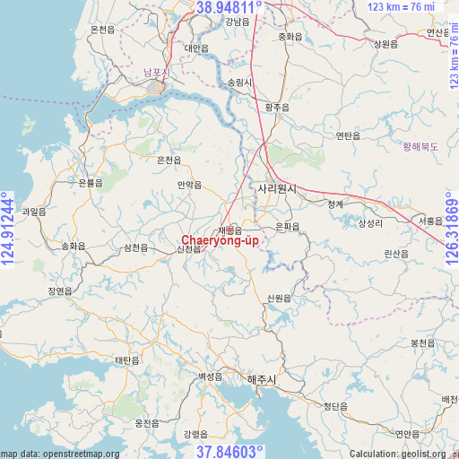
Chaeryŏng-ŭp GPS coordinates[2]
38° 23' 57.012" North, 125° 36' 56.016" East
| Map corner | latitude | longitude |
|---|---|---|
| Upper-left | 38.94811°, | 124.91244° |
| Center: | 38.39917°, | 125.61556° |
| Lower-right: | 37.84603°, | 126.31869° |
| Map W x H: | 122.5×122.5 km | = 76.1×76.1mi |
| max Lat: | 42.95722° ⇑92.3% North |
| Chaeryŏng-ŭp: | 38.39917° |
| min Lat: | ⇓7.7% South 37.90889° |
| min Long | Chaeryŏng-ŭp | max Long |
| 124.39806° | 125.61556° | 130.49522° |
| W 17.6%⇐ | ⇒82.4% E |
Elevation
Elevation of Chaeryŏng-ŭp is 17 m = 56 ft, and this is 114.7 m = 376 ft below average elevation for this country.
| Max E: |
1466 m = 4810 ft | 76.9% |
| Avg. | 131.7 m = 432 ft | |
| Chaeryŏng-ŭp | 17 m = 56 ft | |
Min E: |
1 m = 3 ft | 23.1% |
See also: Chaeryŏng-ŭp elevation on elevation.city.
Geographical zone
Chaeryŏng-ŭp is located in North temperate zone (between Tropic of Cancer and the Arctic Circle). Distance of this Northern Tropic circle is 1663.7 km =1033.8 mi to South.| Distance of | km | miles | from Chaeryŏng-ŭp |
|---|---|---|---|
| North Pole | 5737.5 | 3565.1 | to North |
| Arctic Circle | 3131.6 | 1945.9 | to North |
| Tropic Cancer | 1663.7 | 1033.8 | to South |
| Equator | 4269.6 | 2653 | to South |


Nearby cities:
15 places around Chaeryŏng-ŭp: (largest is in red/bold)
• Anak
16.3 km =10.1 mi,  319°
319°
• Ayang-ni
22.5 km =14 mi,  140°
140°
• Changyŏn
48.2 km =30 mi,  249°
249°
• Chunghwa
54.1 km =33.6 mi,  17°
17°
• Haeju
40.8 km =25.4 mi,  167°
167°
• Hwangju-ŭp
33.2 km =20.6 mi, 24°
• Hŭkkyo-ri
47 km =29.2 mi, 19°
• Namp’o
41.7 km =25.9 mi,  334°
334°
• Ongjin
56.2 km =34.9 mi,  203°
203°
• Pyongyang
71.6 km =44.5 mi,  9°
9°
• Pyŏksŏng-ŭp
39.4 km =24.5 mi,  187°
187°
• Sariwŏn
17.1 km =10.6 mi,  45°
45°
• Sinmak
53.9 km =33.5 mi,  87°
87°
• Songnim
39.6 km =24.6 mi,  3°
3°
• Yonggang-ŭp
53.5 km =33.2 mi,  341°
341°
Sources, notices
• [Note1] Compared only with cities in North Korea existing in our database
• [Src1] Map data: © OpenStreetMap contributors (CC-BY-SA)
• [Src2] Other city data from geonames.org with taken over terms of usage.
• [Src3] Geographical zone / Annual Mean Temperature by Robert A. Rohde @ Wikipedia
