Hŭkkyo-ri geodata
Hŭkkyo-ri (Hwanghae-bukto) is a populated place; located in North Korea in Asia/Pyongyang (GMT+9) time zone. With population of 25,437 people, there are 39 cities with bigger population in this country. Compared to other cities in North Korea, 82.4% of cities are located further ↑North; 71.4% of cities are located further →East and 74.7% of cities have higher elevation than Hŭkkyo-ri. Note1


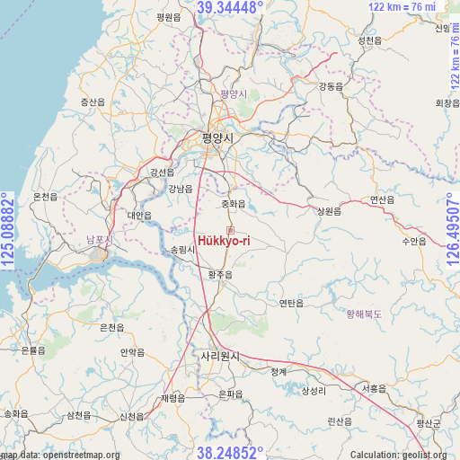
Hŭkkyo-ri GPS coordinates[2]
38° 47' 54.996" North, 125° 47' 30.984" East
| Map corner | latitude | longitude |
|---|---|---|
| Upper-left | 39.34448°, | 125.08882° |
| Center: | 38.79861°, | 125.79194° |
| Lower-right: | 38.24852°, | 126.49507° |
| Map W x H: | 121.9×121.9 km | = 75.7×75.7mi |
| max Lat: | 42.95722° ⇑82.4% North |
| Hŭkkyo-ri: | 38.79861° |
| min Lat: | ⇓17.6% South 37.90889° |
| min Long | Hŭkkyo-ri | max Long |
| 124.39806° | 125.79194° | 130.49522° |
| W 28.6%⇐ | ⇒71.4% E |
Elevation
Elevation of Hŭkkyo-ri is 18 m = 59 ft, and this is 113.7 m = 373 ft below average elevation for this country.
| Max E: |
1466 m = 4810 ft | 74.7% |
| Avg. | 131.7 m = 432 ft | |
| Hŭkkyo-ri | 18 m = 59 ft | |
Min E: |
1 m = 3 ft | 25.3% |
See also: North Korea elevation on elevation.city.
Geographical zone
Hŭkkyo-ri is located in North temperate zone (between Tropic of Cancer and the Arctic Circle). Distance of this Northern Tropic circle is 1708.1 km =1061.4 mi to South.| Distance of | km | miles | from Hŭkkyo-ri |
|---|---|---|---|
| North Pole | 5693.1 | 3537.5 | to North |
| Arctic Circle | 3087.2 | 1918.3 | to North |
| Tropic Cancer | 1708.1 | 1061.4 | to South |
| Equator | 4314 | 2680.6 | to South |


Nearby cities:
15 places around Hŭkkyo-ri: (largest is in red/bold)
• Anak
41.1 km =25.5 mi,  218°
218°
• Ayang-ni
61.8 km =38.4 mi,  180°
180°
• Chaeryŏng-ŭp
47 km =29.2 mi,  199°
199°
• Chunghwa
7.3 km =4.5 mi,  5°
5°
• Hwangju-ŭp
14.3 km =8.9 mi,  185°
185°
• Kangdong-ŭp
46.4 km =28.8 mi,  34°
34°
• Namp’o
34 km =21.1 mi,  258°
258°
• Pyongyang
26.4 km =16.4 mi,  352°
352°
• P’yŏngsŏng
50.3 km =31.3 mi, 7°
• Sariwŏn
32.6 km =20.3 mi, 185°
• Sinmak
57.2 km =35.5 mi,  137°
137°
• Songnim
13.7 km =8.5 mi,  248°
248°
• Sunan
45.3 km =28.1 mi, 348°
• Sŭngho 1-tong
26.8 km =16.7 mi,  36°
36°
• Yonggang-ŭp
32.5 km =20.2 mi,  281°
281°
Sources, notices
• [Note1] Compared only with cities in North Korea existing in our database
• [Src1] Map data: © OpenStreetMap contributors (CC-BY-SA)
• [Src2] Other city data from geonames.org with taken over terms of usage.
• [Src3] Geographical zone / Annual Mean Temperature by Robert A. Rohde @ Wikipedia
