Songnim geodata
Songnim (Hwanghae-bukto) is a populated place; located in North Korea in Asia/Pyongyang (GMT+9) time zone. With population of 152,425 people, there are 13 cities with bigger population in this country. Compared to other cities in North Korea, 84.6% of cities are located further ↑North; 81.3% of cities are located further →East and 68.1% of cities have higher elevation than Songnim. Note1


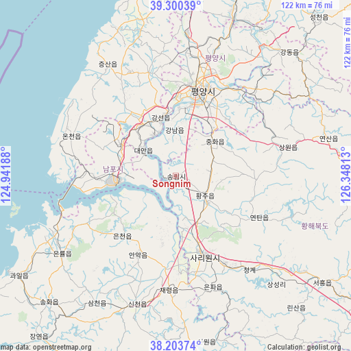
Songnim GPS coordinates[2]
38° 45' 15.012" North, 125° 38' 42" East
| Map corner | latitude | longitude |
|---|---|---|
| Upper-left | 39.30039°, | 124.94188° |
| Center: | 38.75417°, | 125.645° |
| Lower-right: | 38.20374°, | 126.34813° |
| Map W x H: | 121.9×121.9 km | = 75.7×75.7mi |
| max Lat: | 42.95722° ⇑84.6% North |
| Songnim: | 38.75417° |
| min Lat: | ⇓15.4% South 37.90889° |
| min Long | Songnim | max Long |
| 124.39806° | 125.645° | 130.49522° |
| W 18.7%⇐ | ⇒81.3% E |
Elevation
Elevation of Songnim is 21 m = 69 ft, and this is 110.7 m = 363 ft below average elevation for this country.
| Max E: |
1466 m = 4810 ft | 68.1% |
| Avg. | 131.7 m = 432 ft | |
| Songnim | 21 m = 69 ft | |
Min E: |
1 m = 3 ft | 31.9% |
See also: Songnim elevation on elevation.city.
Geographical zone
Songnim is located in North temperate zone (between Tropic of Cancer and the Arctic Circle). Distance of this Northern Tropic circle is 1703.1 km =1058.3 mi to South.| Distance of | km | miles | from Songnim |
|---|---|---|---|
| North Pole | 5698 | 3540.6 | to North |
| Arctic Circle | 3092.1 | 1921.3 | to North |
| Tropic Cancer | 1703.1 | 1058.3 | to South |
| Equator | 4309.1 | 2677.5 | to South |


Nearby cities:
15 places around Songnim: (largest is in red/bold)
• Anak
30.1 km =18.7 mi,  205°
205°
• Ayang-ni
58 km =36 mi,  168°
168°
• Chaeryŏng-ŭp
39.6 km =24.6 mi,  183°
183°
• Chunghwa
18.1 km =11.2 mi,  47°
47°
• Hwangju-ŭp
14.7 km =9.1 mi,  129°
129°
• Hŭkkyo-ri
13.7 km =8.5 mi,  68°
68°
• Kangdong-ŭp
58.2 km =36.2 mi,  42°
42°
• Namp’o
20.7 km =12.9 mi,  264°
264°
• Pyongyang
32.5 km =20.2 mi,  16°
16°
• P’yŏngsŏng
58.1 km =36.1 mi, 19°
• Sariwŏn
29.1 km =18.1 mi,  160°
160°
• Sinmak
63.4 km =39.4 mi, 126°
• Sunan
49.5 km =30.8 mi,  4°
4°
• Sŭngho 1-tong
39.1 km =24.3 mi, 47°
• Yonggang-ŭp
22.2 km =13.8 mi,  300°
300°
Sources, notices
• [Note1] Compared only with cities in North Korea existing in our database
• [Src1] Map data: © OpenStreetMap contributors (CC-BY-SA)
• [Src2] Other city data from geonames.org with taken over terms of usage.
• [Src3] Geographical zone / Annual Mean Temperature by Robert A. Rohde @ Wikipedia
