Haeju geodata
Haeju (Hwanghae-namdo) is a seat of a first-order administrative division; located in North Korea in Asia/Pyongyang (GMT+9) time zone. With population of 222,396 people, there are 10 cities with bigger population in this country. Compared to other cities in North Korea, 96.7% of cities are located further ↑North; 78% of cities are located further →East and 56% of cities have lower elevation than Haeju. Note1


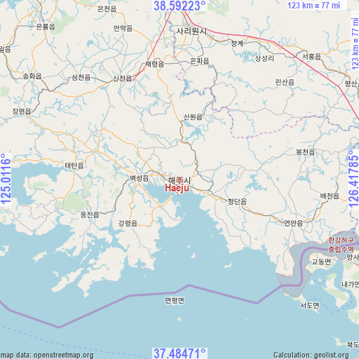
Haeju GPS coordinates[2]
38° 2' 26.016" North, 125° 42' 52.992" East
| Map corner | latitude | longitude |
|---|---|---|
| Upper-left | 38.59223°, | 125.0116° |
| Center: | 38.04056°, | 125.71472° |
| Lower-right: | 37.48471°, | 126.41785° |
| Map W x H: | 123.1×123.1 km | = 76.5×76.5mi |
| max Lat: | 42.95722° ⇑96.7% North |
| Haeju: | 38.04056° |
| min Lat: | ⇓3.3% South 37.90889° |
| min Long | Haeju | max Long |
| 124.39806° | 125.71472° | 130.49522° |
| W 22%⇐ | ⇒78% E |
Elevation
Elevation of Haeju is 57 m = 187 ft, and this is 74.7 m = 245 ft below average elevation for this country.
| Max E: |
1466 m = 4810 ft | 44% |
| Avg. | 131.7 m = 432 ft | |
| Haeju | 57 m = 187 ft | |
Min E: |
1 m = 3 ft | 56% |
See also: Haeju elevation on elevation.city.
Geographical zone
Haeju is located in North temperate zone (between Tropic of Cancer and the Arctic Circle). Distance of this Northern Tropic circle is 1623.8 km =1009 mi to South.| Distance of | km | miles | from Haeju |
|---|---|---|---|
| North Pole | 5777.3 | 3589.8 | to North |
| Arctic Circle | 3171.5 | 1970.7 | to North |
| Tropic Cancer | 1623.8 | 1009 | to South |
| Equator | 4229.7 | 2628.2 | to South |


Nearby cities:
15 places around Haeju: (largest is in red/bold)
• Anak
55.7 km =34.6 mi,  339°
339°
• Ayang-ni
23.2 km =14.4 mi,  14°
14°
• Chaeryŏng-ŭp
40.8 km =25.4 mi,  347°
347°
• Changyŏn
58.9 km =36.6 mi,  293°
293°
• Chunghwa
91.8 km =57 mi,  4°
4°
• Hwangju-ŭp
70.2 km =43.6 mi, 4°
• Hŭkkyo-ri
84.6 km =52.6 mi, 4°
• Kaesŏng
74 km =46 mi,  96°
96°
• Namp’o
82 km =51 mi, 340°
• Ongjin
33.1 km =20.6 mi,  249°
249°
• Pyŏksŏng-ŭp
13.9 km =8.6 mi,  273°
273°
• Sariwŏn
52 km =32.3 mi, 3°
• Sinmak
61.7 km =38.3 mi,  47°
47°
• Songnim
79.6 km =49.5 mi,  355°
355°
• Yŏnan-ŭp
41.8 km =26 mi,  110°
110°
Sources, notices
• [Note1] Compared only with cities in North Korea existing in our database
• [Src1] Map data: © OpenStreetMap contributors (CC-BY-SA)
• [Src2] Other city data from geonames.org with taken over terms of usage.
• [Src3] Geographical zone / Annual Mean Temperature by Robert A. Rohde @ Wikipedia
