Uijeongbu-si geodata
Uijeongbu-si (Gyeonggi-do) is a populated place; located in South Korea in Asia/Seoul (GMT+9) time zone. With population of 479,141 people, there are 17 cities with bigger population in this country. Compared to other cities in South Korea, 89.5% of cities are located further ↓South; 63.6% of cities are located further →East and 57% of cities have lower elevation than Uijeongbu-si. Note1


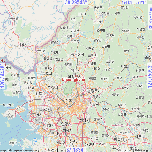
Uijeongbu-si GPS coordinates[2]
37° 44' 29.4" North, 127° 2' 50.64" East
| Map corner | latitude | longitude |
|---|---|---|
| Upper-left | 38.29543°, | 126.34428° |
| Center: | 37.7415°, | 127.0474° |
| Lower-right: | 37.1834°, | 127.75053° |
| Map W x H: | 123.6×123.6 km | = 76.8×76.8mi |
| max Lat: | 38.37881° ⇑10.5% North |
| Uijeongbu-si: | 37.7415° |
| min Lat: | ⇓89.5% South 33.25333° |
| min Long | Uijeongbu-si | max Long |
| 126.10863° | 127.0474° | 129.55377° |
| W 36.4%⇐ | ⇒63.6% E |
Elevation
Elevation of Uijeongbu-si is 50 m = 164 ft, and this is 20.4 m = 67 ft below average elevation for this country.
| Max E: |
691 m = 2267 ft | 43% |
| Avg. | 70.4 m = 231 ft | |
| Uijeongbu-si | 50 m = 164 ft | |
Min E: |
1 m = 3 ft | 57% |
See also: Uijeongbu-si elevation on elevation.city.
Geographical zone
Uijeongbu-si is located in North temperate zone (between Tropic of Cancer and the Arctic Circle). Distance of this Northern Tropic circle is 1590.5 km =988.3 mi to South.| Distance of | km | miles | from Uijeongbu-si |
|---|---|---|---|
| North Pole | 5810.6 | 3610.5 | to North |
| Arctic Circle | 3204.7 | 1991.3 | to North |
| Tropic Cancer | 1590.5 | 988.3 | to South |
| Equator | 4196.5 | 2607.6 | to South |


Nearby cities:
15 places around Uijeongbu-si: (largest is in red/bold)
• Beobwon
19.3 km =12 mi,  308°
308°
• Goyang-si
20.9 km =13 mi,  243°
243°
• Guri-si
17.8 km =11.1 mi,  152°
152°
• Gwangjeok
10.9 km =6.8 mi,  329°
329°
• Gwangtan
17.9 km =11.1 mi,  284°
284°
• Jangheung
9.7 km =6 mi,  253°
253°
• Jinjeop
12.6 km =7.8 mi,  97°
97°
• Namyangju
18.7 km =11.6 mi,  128°
128°
• Onam
14.7 km =9.1 mi,  109°
109°
• Paju
22.7 km =14.1 mi,  296°
296°
• Seoul
20.4 km =12.7 mi,  197°
197°
• Su-dong
24.8 km =15.4 mi, 99°
• Wabu
22.7 km =14.1 mi,  137°
137°
• Yangju
10.3 km =6.4 mi,  7°
7°
• Yongsan-dong
22.6 km =14 mi,  194°
194°
Sources, notices
• [Note1] Compared only with cities in South Korea existing in our database
• [Src1] Map data: © OpenStreetMap contributors (CC-BY-SA)
• [Src2] Other city data from geonames.org with taken over terms of usage.
• [Src3] Geographical zone / Annual Mean Temperature by Robert A. Rohde @ Wikipedia
