Seoul geodata
Seoul is a capital of a political entity; located in South Korea in Asia/Seoul (GMT+9) time zone. With population of 10,349,312 people, there are 0 cities with bigger population in this country. Compared to other cities in South Korea, 82.2% of cities are located further ↓South; 68.5% of cities are located further →East and 52.4% of cities have higher elevation than Seoul. Note1


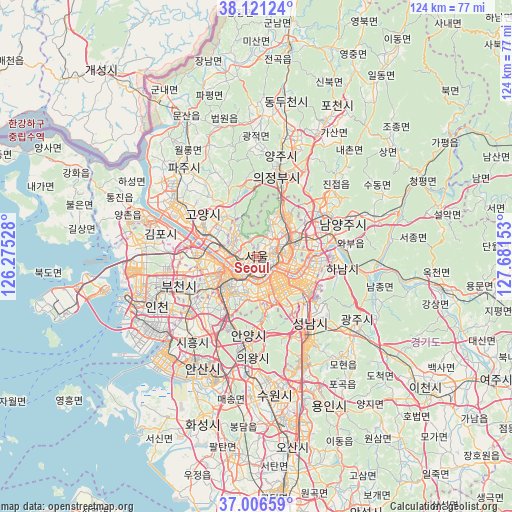
Seoul GPS coordinates[2]
37° 33' 57.6" North, 126° 58' 42.24" East
| Map corner | latitude | longitude |
|---|---|---|
| Upper-left | 38.12124°, | 126.27528° |
| Center: | 37.566°, | 126.9784° |
| Lower-right: | 37.00659°, | 127.68153° |
| Map W x H: | 123.9×123.9 km | = 77×77mi |
| max Lat: | 38.37881° ⇑17.8% North |
| Seoul: | 37.566° |
| min Lat: | ⇓82.2% South 33.25333° |
| min Long | Seoul | max Long |
| 126.10863° | 126.9784° | 129.55377° |
| W 31.5%⇐ | ⇒68.5% E |
Elevation
Elevation of Seoul is 38 m = 125 ft, and this is 32.4 m = 106 ft below average elevation for this country.
| Max E: |
691 m = 2267 ft | 52.4% |
| Avg. | 70.4 m = 231 ft | |
| Seoul | 38 m = 125 ft | |
Min E: |
1 m = 3 ft | 47.6% |
See also: Seoul elevation on elevation.city.
Geographical zone
Seoul is located in North temperate zone (between Tropic of Cancer and the Arctic Circle). Distance of this Northern Tropic circle is 1571 km =976.2 mi to South.| Distance of | km | miles | from Seoul |
|---|---|---|---|
| North Pole | 5830.1 | 3622.7 | to North |
| Arctic Circle | 3224.2 | 2003.4 | to North |
| Tropic Cancer | 1571 | 976.2 | to South |
| Equator | 4176.9 | 2595.4 | to South |


Nearby cities:
15 places around Seoul: (largest is in red/bold)
• Anyang-si
19.8 km =12.3 mi,  193°
193°
• Bucheon-si
18.8 km =11.7 mi,  246°
246°
• Bupyeong
23.6 km =14.7 mi, 253°
• Goyang-si
16.1 km =10 mi,  308°
308°
• Guri-si
14.6 km =9.1 mi,  75°
75°
• Hanam
20.2 km =12.6 mi,  98°
98°
• Jangheung
17.1 km =10.6 mi,  348°
348°
• Kwangmyŏng
14 km =8.7 mi,  225°
225°
• Namyangju
22.2 km =13.8 mi,  69°
69°
• Onam
24.8 km =15.4 mi,  53°
53°
• Paripark
9.6 km =6 mi, 248°
• Seongnam-si
20 km =12.4 mi,  135°
135°
• Uijeongbu-si
20.4 km =12.7 mi,  17°
17°
• Wabu
21.5 km =13.4 mi, 82°
• Yongsan-dong
2.4 km =1.5 mi,  168°
168°
In other languages:
- In Spanish: Seúl
- In France: Séoul
- In Italian: Seul
- In Russian: Сеул
- In Chinese: 首尔特别市
Sources, notices
• [Note1] Compared only with cities in South Korea existing in our database
• [Src1] Map data: © OpenStreetMap contributors (CC-BY-SA)
• [Src2] Other city data from geonames.org with taken over terms of usage.
• [Src3] Geographical zone / Annual Mean Temperature by Robert A. Rohde @ Wikipedia
