Gwangju geodata
Gwangju is a seat of a first-order administrative division; located in South Korea in Asia/Seoul (GMT+9) time zone. With population of 1,416,938 people, there are 5 cities with bigger population in this country. Compared to other cities in South Korea, 74.5% of cities are located further ↑North; 71% of cities are located further →East and 53.8% of cities have lower elevation than Gwangju. Note1


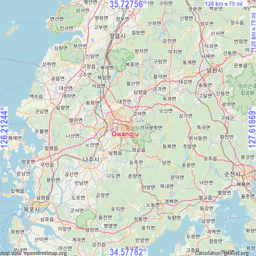
Gwangju GPS coordinates[2]
35° 9' 16.992" North, 126° 54' 56.016" East
| Map corner | latitude | longitude |
|---|---|---|
| Upper-left | 35.72756°, | 126.21244° |
| Center: | 35.15472°, | 126.91556° |
| Lower-right: | 34.57782°, | 127.61869° |
| Map W x H: | 127.8×127.8 km | = 79.4×79.4mi |
| max Lat: | 38.37881° ⇑74.5% North |
| Gwangju: | 35.15472° |
| min Lat: | ⇓25.5% South 33.25333° |
| min Long | Gwangju | max Long |
| 126.10863° | 126.91556° | 129.55377° |
| W 29%⇐ | ⇒71% E |
Elevation
Elevation of Gwangju is 47 m = 154 ft, and this is 23.4 m = 77 ft below average elevation for this country.
| Max E: |
691 m = 2267 ft | 46.2% |
| Avg. | 70.4 m = 231 ft | |
| Gwangju | 47 m = 154 ft | |
Min E: |
1 m = 3 ft | 53.8% |
See also: Gwangju elevation on elevation.city.
Geographical zone
Gwangju is located in North temperate zone (between Tropic of Cancer and the Arctic Circle). Distance of this Northern Tropic circle is 1302.9 km =809.6 mi to South.| Distance of | km | miles | from Gwangju |
|---|---|---|---|
| North Pole | 6098.2 | 3789.2 | to North |
| Arctic Circle | 3492.3 | 2170 | to North |
| Tropic Cancer | 1302.9 | 809.6 | to South |
| Equator | 3908.8 | 2428.8 | to South |


Nearby cities:
15 places around Gwangju: (largest is in red/bold)
• Changpyeong
13.2 km =8.2 mi,  44°
44°
• Damyang
19.3 km =12 mi,  18°
18°
• Dongbok
21.7 km =13.5 mi,  115°
115°
• Dongmyeon
17.7 km =11 mi,  140°
140°
• Haebo
28.7 km =17.8 mi,  275°
275°
• Hancheolli
21.5 km =13.4 mi,  158°
158°
• Hwasun
12.3 km =7.6 mi,  147°
147°
• Iyang
30.2 km =18.8 mi,  167°
167°
• Jangseong
19.9 km =12.4 mi,  323°
323°
• Juam
30.3 km =18.8 mi,  106°
106°
• Masan
8.2 km =5.1 mi,  248°
248°
• Naju
22.8 km =14.2 mi,  232°
232°
• Nammyeon
23.2 km =14.4 mi,  134°
134°
• Nasan
28.2 km =17.5 mi,  260°
260°
• Seji
30.2 km =18.8 mi,  210°
210°
Sources, notices
• [Note1] Compared only with cities in South Korea existing in our database
• [Src1] Map data: © OpenStreetMap contributors (CC-BY-SA)
• [Src2] Other city data from geonames.org with taken over terms of usage.
• [Src3] Geographical zone / Annual Mean Temperature by Robert A. Rohde @ Wikipedia
