Bangsan geodata
Bangsan (Gangwon-do) is a seat of a third-order administrative division; located in South Korea in Asia/Seoul (GMT+9) time zone. In our database, there are 128 cities with bigger population. Compared to other cities in South Korea, 98.6% of cities are located further ↓South; 77.3% of cities are located further ←West and 96.5% of cities have lower elevation than Bangsan. Note1


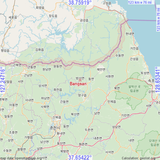
Bangsan GPS coordinates[2]
38° 12' 31.68" North, 127° 57' 1.008" East
| Map corner | latitude | longitude |
|---|---|---|
| Upper-left | 38.75919°, | 127.24716° |
| Center: | 38.2088°, | 127.95028° |
| Lower-right: | 37.65422°, | 128.65341° |
| Map W x H: | 122.9×122.9 km | = 76.4×76.4mi |
| max Lat: | 38.37881° ⇑1.4% North |
| Bangsan: | 38.2088° |
| min Lat: | ⇓98.6% South 33.25333° |
| min Long | Bangsan | max Long |
| 126.10863° | 127.95028° | 129.55377° |
| W 77.3%⇐ | ⇒22.7% E |
Elevation
Elevation of Bangsan is 257 m = 843 ft, and this is 186.6 m = 612 ft above average elevation for this country.
| Max E: |
691 m = 2267 ft | 3.5% |
| Bangsan | 257 m 843 ft | |
| Avg. | 70.4 m = 231 ft | |
Min E: |
1 m = 3 ft | 96.5% |
See also: South Korea elevation on elevation.city.
Geographical zone
Bangsan is located in North temperate zone (between Tropic of Cancer and the Arctic Circle). Distance of this Northern Tropic circle is 1642.5 km =1020.6 mi to South.| Distance of | km | miles | from Bangsan |
|---|---|---|---|
| North Pole | 5758.6 | 3578.2 | to North |
| Arctic Circle | 3152.8 | 1959.1 | to North |
| Tropic Cancer | 1642.5 | 1020.6 | to South |
| Equator | 4248.4 | 2639.8 | to South |


Nearby cities:
15 places around Bangsan: (largest is in red/bold)
• Cheorwon
64 km =39.8 mi,  270°
270°
• Chuncheon
41.7 km =25.9 mi,  206°
206°
• Dongmyeon
8.2 km =5.1 mi,  95°
95°
• Dongnae
43.4 km =27 mi,  202°
202°
• Gapyeong
57 km =35.4 mi,  222°
222°
• Gwanin
61.5 km =38.2 mi,  264°
264°
• Haean
18.5 km =11.5 mi,  62°
62°
• Hongch’ŏn
57.8 km =35.9 mi,  185°
185°
• Hwacheon
24.1 km =15 mi,  242°
242°
• Kosong
48.9 km =30.4 mi,  67°
67°
• Seoseok
59 km =36.7 mi,  159°
159°
• Sindong
48.1 km =29.9 mi, 205°
• Sokcho
56.1 km =34.9 mi,  90°
90°
• Toseong
53.5 km =33.2 mi,  84°
84°
• Yanggu
12 km =7.5 mi, 163°
Sources, notices
• [Note1] Compared only with cities in South Korea existing in our database
• [Src1] Map data: © OpenStreetMap contributors (CC-BY-SA)
• [Src2] Other city data from geonames.org with taken over terms of usage.
• [Src3] Geographical zone / Annual Mean Temperature by Robert A. Rohde @ Wikipedia
