Chuncheon geodata
Chuncheon (Gangwon-do) is a seat of a first-order administrative division; located in South Korea in Asia/Seoul (GMT+9) time zone. With population of 209,746 people, there are 33 cities with bigger population in this country. Compared to other cities in South Korea, 95.5% of cities are located further ↓South; 71.7% of cities are located further ←West and 74.1% of cities have lower elevation than Chuncheon. Note1


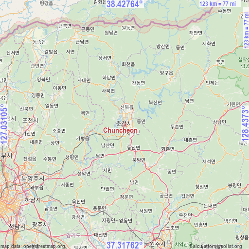
Chuncheon GPS coordinates[2]
37° 52' 28.992" North, 127° 44' 3.012" East
| Map corner | latitude | longitude |
|---|---|---|
| Upper-left | 38.42764°, | 127.03105° |
| Center: | 37.87472°, | 127.73417° |
| Lower-right: | 37.31762°, | 128.4373° |
| Map W x H: | 123.4×123.4 km | = 76.7×76.7mi |
| max Lat: | 38.37881° ⇑4.5% North |
| Chuncheon: | 37.87472° |
| min Lat: | ⇓95.5% South 33.25333° |
| min Long | Chuncheon | max Long |
| 126.10863° | 127.73417° | 129.55377° |
| W 71.7%⇐ | ⇒28.3% E |
Elevation
Elevation of Chuncheon is 92 m = 302 ft, and this is 21.6 m = 71 ft above average elevation for this country.
| Max E: |
691 m = 2267 ft | 25.9% |
| Chuncheon | 92 m 302 ft | |
| Avg. | 70.4 m = 231 ft | |
Min E: |
1 m = 3 ft | 74.1% |
See also: Chuncheon elevation on elevation.city.
Geographical zone
Chuncheon is located in North temperate zone (between Tropic of Cancer and the Arctic Circle). Distance of this Northern Tropic circle is 1605.4 km =997.5 mi to South.| Distance of | km | miles | from Chuncheon |
|---|---|---|---|
| North Pole | 5795.8 | 3601.3 | to North |
| Arctic Circle | 3189.9 | 1982.1 | to North |
| Tropic Cancer | 1605.4 | 997.5 | to South |
| Equator | 4211.3 | 2616.8 | to South |


Nearby cities:
15 places around Chuncheon: (largest is in red/bold)
• Bangsan
41.7 km =25.9 mi,  26°
26°
• Cheongpyeong
31.8 km =19.8 mi,  240°
240°
• Dongmyeon
45.3 km =28.1 mi,  36°
36°
• Dongnae
3.9 km =2.4 mi,  141°
141°
• Gapyeong
20.2 km =12.6 mi,  256°
256°
• Hongch’ŏn
24.3 km =15.1 mi,  146°
146°
• Hwacheon
25.9 km =16.1 mi,  354°
354°
• Hwado
44.9 km =27.9 mi, 236°
• Jinjeop
50.5 km =31.4 mi,  251°
251°
• Onam
50.4 km =31.3 mi, 247°
• Seoseok
43.7 km =27.2 mi,  114°
114°
• Sindong
6.6 km =4.1 mi,  193°
193°
• Su-dong
40.6 km =25.2 mi, 242°
• Yanggu
34.1 km =21.2 mi, 41°
• Yangp'yŏng
47.9 km =29.8 mi,  206°
206°
Sources, notices
• [Note1] Compared only with cities in South Korea existing in our database
• [Src1] Map data: © OpenStreetMap contributors (CC-BY-SA)
• [Src2] Other city data from geonames.org with taken over terms of usage.
• [Src3] Geographical zone / Annual Mean Temperature by Robert A. Rohde @ Wikipedia
