Sokcho geodata
Sokcho (Gangwon-do) is a seat of a second-order administrative division; located in South Korea in Asia/Seoul (GMT+9) time zone. With population of 89,047 people, there are 53 cities with bigger population in this country. Compared to other cities in South Korea, 98.3% of cities are located further ↓South; 87.8% of cities are located further ←West and 72% of cities have higher elevation than Sokcho. Note1


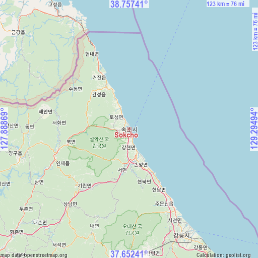
Sokcho GPS coordinates[2]
38° 12' 25.236" North, 128° 35' 30.516" East
| Map corner | latitude | longitude |
|---|---|---|
| Upper-left | 38.75741°, | 127.88869° |
| Center: | 38.20701°, | 128.59181° |
| Lower-right: | 37.65241°, | 129.29494° |
| Map W x H: | 122.9×122.9 km | = 76.4×76.4mi |
| max Lat: | 38.37881° ⇑1.7% North |
| Sokcho: | 38.20701° |
| min Lat: | ⇓98.3% South 33.25333° |
| min Long | Sokcho | max Long |
| 126.10863° | 128.59181° | 129.55377° |
| W 87.8%⇐ | ⇒12.2% E |
Elevation
Elevation of Sokcho is 20 m = 66 ft, and this is 50.4 m = 165 ft below average elevation for this country.
| Max E: |
691 m = 2267 ft | 72% |
| Avg. | 70.4 m = 231 ft | |
| Sokcho | 20 m = 66 ft | |
Min E: |
1 m = 3 ft | 28% |
See also: Sokcho elevation on elevation.city.
Geographical zone
Sokcho is located in North temperate zone (between Tropic of Cancer and the Arctic Circle). Distance of this Northern Tropic circle is 1642.3 km =1020.5 mi to South.| Distance of | km | miles | from Sokcho |
|---|---|---|---|
| North Pole | 5758.8 | 3578.4 | to North |
| Arctic Circle | 3153 | 1959.2 | to North |
| Tropic Cancer | 1642.3 | 1020.5 | to South |
| Equator | 4248.2 | 2639.7 | to South |


Nearby cities:
15 places around Sokcho: (largest is in red/bold)
• Bangsan
56.1 km =34.9 mi,  270°
270°
• Chuncheon
83.7 km =52 mi,  243°
243°
• Dongmyeon
47.9 km =29.8 mi, 269°
• Dongnae
83 km =51.6 mi, 241°
• Gangdong
61.9 km =38.5 mi,  149°
149°
• Gangneung
56.2 km =34.9 mi, 154°
• Gujeong
59.8 km =37.2 mi,  155°
155°
• Haean
40.6 km =25.2 mi,  282°
282°
• Hongch’ŏn
84.3 km =52.4 mi,  227°
227°
• Hwacheon
78.2 km =48.6 mi,  261°
261°
• Kosong
22 km =13.7 mi,  330°
330°
• Seoseok
65.5 km =40.7 mi,  212°
212°
• Tonghae
86.5 km =53.7 mi, 148°
• Toseong
6.2 km =3.9 mi, 333°
• Yanggu
53.9 km =33.5 mi, 257°
Sources, notices
• [Note1] Compared only with cities in South Korea existing in our database
• [Src1] Map data: © OpenStreetMap contributors (CC-BY-SA)
• [Src2] Other city data from geonames.org with taken over terms of usage.
• [Src3] Geographical zone / Annual Mean Temperature by Robert A. Rohde @ Wikipedia
