Karagandy geodata
Karagandy (Karaganda) is a seat of a first-order administrative division; located in Kazakhstan in Asia/Almaty (GMT+5) time zone. With population of 451,800 people, there is 1 city with bigger population in this country. Compared to other cities in Kazakhstan, 63.3% of cities are located further ↓South; 65.2% of cities are located further ←West and 78.5% of cities have lower elevation than Karagandy. Note1


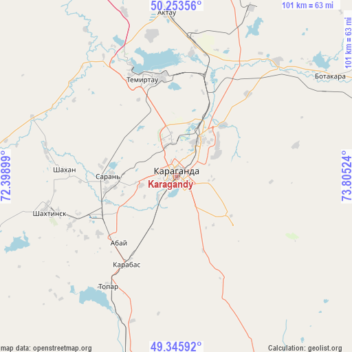
Karagandy GPS coordinates[2]
49° 48' 6.732" North, 73° 6' 7.596" East
| Map corner | latitude | longitude |
|---|---|---|
| Upper-left | 50.25356°, | 72.39899° |
| Center: | 49.80187°, | 73.10211° |
| Lower-right: | 49.34592°, | 73.80524° |
| Map W x H: | 100.9×100.9 km | = 62.7×62.7mi |
| max Lat: | 54.90596° ⇑36.7% North |
| Karagandy: | 49.80187° |
| min Lat: | ⇓63.3% South 40.66338° |
| min Long | Karagandy | max Long |
| 46.83361° | 73.10211° | 84.87144° |
| W 65.2%⇐ | ⇒34.8% E |
Elevation
Elevation of Karagandy is 537 m = 1762 ft, and this is 180.5 m = 592 ft above average elevation for this country.
| Max E: |
1847 m = 6060 ft | 21.5% |
| Karagandy | 537 m 1762 ft | |
| Avg. | 356.5 m = 1170 ft | |
Min E: |
-26 m = -85 ft | 78.5% |
See also: Karagandy elevation on elevation.city.
Geographical zone
Karagandy is located in North temperate zone (between Tropic of Cancer and the Arctic Circle). Distance of this North polar circle is 1863.7 km =1158 mi to North.| Distance of | km | miles | from Karagandy |
|---|---|---|---|
| North Pole | 4469.6 | 2777.3 | to North |
| Arctic Circle | 1863.7 | 1158 | to North |
| Tropic Cancer | 2931.5 | 1821.5 | to South |
| Equator | 5537.4 | 3440.8 | to South |


Nearby cities:
15 places around Karagandy: (largest is in red/bold)
• Abay
25.3 km =15.7 mi,  223°
223°
• Aktas
10.4 km =6.5 mi,  256°
256°
• Aktau
48.2 km =30 mi,  356°
356°
• Dolinka
33.5 km =20.8 mi,  245°
245°
• Koktal
34.2 km =21.3 mi,  119°
119°
• Kushoky
52.3 km =32.5 mi,  24°
24°
• Kyzylzhar
40.7 km =25.3 mi,  299°
299°
• Novodolinskiy
30.2 km =18.8 mi, 249°
• Osakarovka
92.6 km =57.5 mi,  335°
335°
• Shakhan
32.2 km =20 mi,  273°
273°
• Shakhtinsk
38.1 km =23.7 mi, 254°
• Soran
19 km =11.8 mi, 266°
• Temirtau
29.8 km =18.5 mi, 340°
• Tokarevka
35.1 km =21.8 mi,  6°
6°
• Zharyk
106.8 km =66.4 mi,  190°
190°
Sources, notices
• [Note1] Compared only with cities in Kazakhstan existing in our database
• [Src1] Map data: © OpenStreetMap contributors (CC-BY-SA)
• [Src2] Other city data from geonames.org with taken over terms of usage.
• [Src3] Geographical zone / Annual Mean Temperature by Robert A. Rohde @ Wikipedia
