Kushoky geodata
Kushoky (Karaganda) is a populated place; located in Kazakhstan in Asia/Almaty (GMT+5) time zone. With population of 3,920 people, there are 214 cities with bigger population in this country. Compared to other cities in Kazakhstan, 67% of cities are located further ↓South; 67.8% of cities are located further ←West and 77.4% of cities have lower elevation than Kushoky. Note1


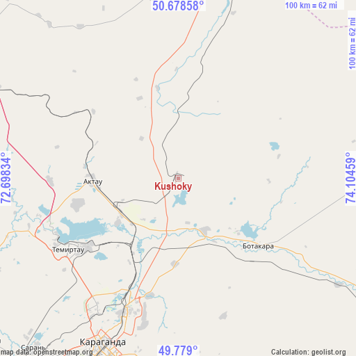
Kushoky GPS coordinates[2]
50° 13' 51.276" North, 73° 24' 5.256" East
| Map corner | latitude | longitude |
|---|---|---|
| Upper-left | 50.67858°, | 72.69834° |
| Center: | 50.23091°, | 73.40146° |
| Lower-right: | 49.779°, | 74.10459° |
| Map W x H: | 100×100 km | = 62.1×62.1mi |
| max Lat: | 54.90596° ⇑33% North |
| Kushoky: | 50.23091° |
| min Lat: | ⇓67% South 40.66338° |
| min Long | Kushoky | max Long |
| 46.83361° | 73.40146° | 84.87144° |
| W 67.8%⇐ | ⇒32.2% E |
Elevation
Elevation of Kushoky is 516 m = 1693 ft, and this is 159.5 m = 523 ft above average elevation for this country.
| Max E: |
1847 m = 6060 ft | 22.6% |
| Kushoky | 516 m 1693 ft | |
| Avg. | 356.5 m = 1170 ft | |
Min E: |
-26 m = -85 ft | 77.4% |
See also: Kazakhstan elevation on elevation.city.
Geographical zone
Kushoky is located in North temperate zone (between Tropic of Cancer and the Arctic Circle). Distance of this North polar circle is 1816 km =1128.4 mi to North.| Distance of | km | miles | from Kushoky |
|---|---|---|---|
| North Pole | 4421.9 | 2747.6 | to North |
| Arctic Circle | 1816 | 1128.4 | to North |
| Tropic Cancer | 2979.2 | 1851.2 | to South |
| Equator | 5585.2 | 3470.5 | to South |


Nearby cities:
15 places around Kushoky: (largest is in red/bold)
• Abay
76.6 km =47.6 mi,  210°
210°
• Aktas
59.2 km =36.8 mi, 212°
• Aktau
23.8 km =14.8 mi,  271°
271°
• Dolinka
80.5 km =50 mi,  220°
220°
• Karagandy
52.3 km =32.5 mi,  204°
204°
• Koktal
65.1 km =40.5 mi,  172°
172°
• Kyzylzhar
63 km =39.1 mi,  243°
243°
• Kīevka
131.8 km =81.9 mi, 271°
• Novodolinskiy
76.5 km =47.5 mi, 220°
• Osakarovka
69.4 km =43.1 mi,  302°
302°
• Shakhan
70.3 km =43.7 mi,  229°
229°
• Shakhtinsk
82 km =51 mi, 224°
• Soran
63.4 km =39.4 mi, 219°
• Temirtau
36.8 km =22.9 mi, 237°
• Tokarevka
21.4 km =13.3 mi, 233°
Sources, notices
• [Note1] Compared only with cities in Kazakhstan existing in our database
• [Src1] Map data: © OpenStreetMap contributors (CC-BY-SA)
• [Src2] Other city data from geonames.org with taken over terms of usage.
• [Src3] Geographical zone / Annual Mean Temperature by Robert A. Rohde @ Wikipedia
