Shakhtinsk geodata
Shakhtinsk (Karaganda) is a populated place; located in Kazakhstan in Asia/Almaty (GMT+5) time zone. With population of 41,602 people, there are 38 cities with bigger population in this country. Compared to other cities in Kazakhstan, 60.7% of cities are located further ↓South; 58.5% of cities are located further ←West and 73% of cities have lower elevation than Shakhtinsk. Note1


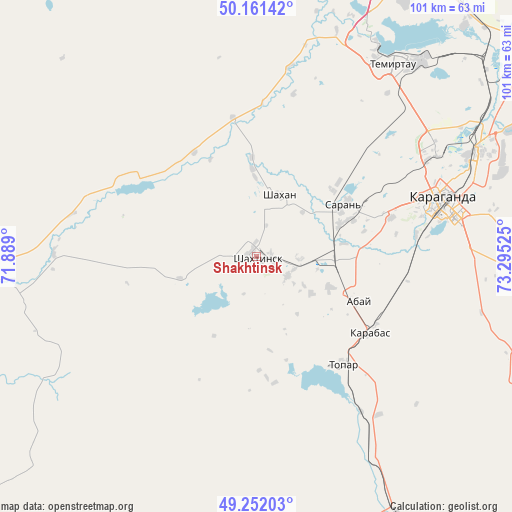
Shakhtinsk GPS coordinates[2]
49° 42' 31.86" North, 72° 35' 31.632" East
| Map corner | latitude | longitude |
|---|---|---|
| Upper-left | 50.16142°, | 71.889° |
| Center: | 49.70885°, | 72.59212° |
| Lower-right: | 49.25203°, | 73.29525° |
| Map W x H: | 101.1×101.1 km | = 62.8×62.8mi |
| max Lat: | 54.90596° ⇑39.3% North |
| Shakhtinsk: | 49.70885° |
| min Lat: | ⇓60.7% South 40.66338° |
| min Long | Shakhtinsk | max Long |
| 46.83361° | 72.59212° | 84.87144° |
| W 58.5%⇐ | ⇒41.5% E |
Elevation
Elevation of Shakhtinsk is 488 m = 1601 ft, and this is 131.5 m = 431 ft above average elevation for this country.
| Max E: |
1847 m = 6060 ft | 27% |
| Shakhtinsk | 488 m 1601 ft | |
| Avg. | 356.5 m = 1170 ft | |
Min E: |
-26 m = -85 ft | 73% |
See also: Shakhtinsk elevation on elevation.city.
Geographical zone
Shakhtinsk is located in North temperate zone (between Tropic of Cancer and the Arctic Circle). Distance of this North polar circle is 1874.1 km =1164.5 mi to North.| Distance of | km | miles | from Shakhtinsk |
|---|---|---|---|
| North Pole | 4480 | 2783.7 | to North |
| Arctic Circle | 1874.1 | 1164.5 | to North |
| Tropic Cancer | 2921.2 | 1815.1 | to South |
| Equator | 5527.1 | 3434.4 | to South |


Nearby cities:
15 places around Shakhtinsk: (largest is in red/bold)
• Abay
21 km =13 mi,  112°
112°
• Aktas
27.7 km =17.2 mi,  73°
73°
• Aktau
67.6 km =42 mi,  30°
30°
• Dolinka
7.1 km =4.4 mi,  119°
119°
• Karagandy
38.1 km =23.7 mi, 74°
• Koktal
66.8 km =41.5 mi,  95°
95°
• Kushoky
82 km =51 mi,  44°
44°
• Kyzylzhar
30.4 km =18.9 mi,  2°
2°
• Novodolinskiy
8.3 km =5.2 mi,  91°
91°
• Osakarovka
94.9 km =59 mi,  359°
359°
• Shakhan
13.1 km =8.1 mi,  19°
19°
• Soran
19.8 km =12.3 mi,  62°
62°
• Temirtau
46.8 km =29.1 mi, 34°
• Tokarevka
60.8 km =37.8 mi, 41°
• Zharyk
96.4 km =59.9 mi,  169°
169°
Sources, notices
• [Note1] Compared only with cities in Kazakhstan existing in our database
• [Src1] Map data: © OpenStreetMap contributors (CC-BY-SA)
• [Src2] Other city data from geonames.org with taken over terms of usage.
• [Src3] Geographical zone / Annual Mean Temperature by Robert A. Rohde @ Wikipedia
