Osakarovka geodata
Osakarovka (Karaganda) is a populated place; located in Kazakhstan in Asia/Almaty (GMT+5) time zone. With population of 7,305 people, there are 150 cities with bigger population in this country. Compared to other cities in Kazakhstan, 71.5% of cities are located further ↓South; 58.1% of cities are located further ←West and 75.6% of cities have lower elevation than Osakarovka. Note1


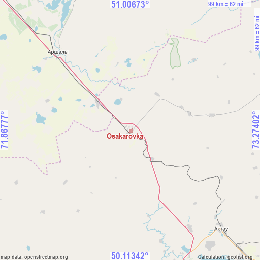
Osakarovka GPS coordinates[2]
50° 33' 43.884" North, 72° 34' 15.204" East
| Map corner | latitude | longitude |
|---|---|---|
| Upper-left | 51.00673°, | 71.86777° |
| Center: | 50.56219°, | 72.57089° |
| Lower-right: | 50.11342°, | 73.27402° |
| Map W x H: | 99.3×99.3 km | = 61.7×61.7mi |
| max Lat: | 54.90596° ⇑28.5% North |
| Osakarovka: | 50.56219° |
| min Lat: | ⇓71.5% South 40.66338° |
| min Long | Osakarovka | max Long |
| 46.83361° | 72.57089° | 84.87144° |
| W 58.1%⇐ | ⇒41.9% E |
Elevation
Elevation of Osakarovka is 506 m = 1660 ft, and this is 149.5 m = 490 ft above average elevation for this country.
| Max E: |
1847 m = 6060 ft | 24.4% |
| Osakarovka | 506 m 1660 ft | |
| Avg. | 356.5 m = 1170 ft | |
Min E: |
-26 m = -85 ft | 75.6% |
See also: Kazakhstan elevation on elevation.city.
Geographical zone
Osakarovka is located in North temperate zone (between Tropic of Cancer and the Arctic Circle). Distance of this North polar circle is 1779.2 km =1105.5 mi to North.| Distance of | km | miles | from Osakarovka |
|---|---|---|---|
| North Pole | 4385.1 | 2724.8 | to North |
| Arctic Circle | 1779.2 | 1105.5 | to North |
| Tropic Cancer | 3016.1 | 1874.1 | to South |
| Equator | 5622 | 3493.3 | to South |


Nearby cities:
15 places around Osakarovka: (largest is in red/bold)
• Abay
105.1 km =65.3 mi,  168°
168°
• Aktas
91.4 km =56.8 mi,  162°
162°
• Aktau
50.6 km =31.4 mi,  136°
136°
• Dolinka
98.7 km =61.3 mi,  175°
175°
• Karagandy
92.6 km =57.5 mi, 155°
• Kushoky
69.4 km =43.1 mi,  122°
122°
• Kyzylzhar
64.6 km =40.1 mi, 177°
• Kīevka
79.8 km =49.6 mi,  245°
245°
• Novodolinskiy
95.6 km =59.4 mi, 174°
• Nur-Sultan
104.6 km =65 mi,  311°
311°
• Shakhan
82.8 km =51.4 mi, 175°
• Shakhtinsk
94.9 km =59 mi, 179°
• Soran
87.8 km =54.6 mi, 167°
• Temirtau
63 km =39.1 mi,  153°
153°
• Tokarevka
64.9 km =40.3 mi, 139°
Sources, notices
• [Note1] Compared only with cities in Kazakhstan existing in our database
• [Src1] Map data: © OpenStreetMap contributors (CC-BY-SA)
• [Src2] Other city data from geonames.org with taken over terms of usage.
• [Src3] Geographical zone / Annual Mean Temperature by Robert A. Rohde @ Wikipedia
