Aktas geodata
Aktas (Karaganda) is a populated place; located in Kazakhstan in Asia/Almaty (GMT+5) time zone. With population of 9,888 people, there are 115 cities with bigger population in this country. Compared to other cities in Kazakhstan, 62.6% of cities are located further ↓South; 63.7% of cities are located further ←West and 80.4% of cities have lower elevation than Aktas. Note1


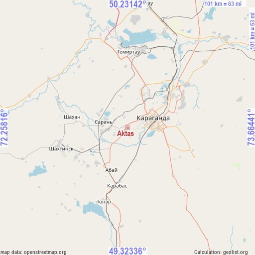
Aktas GPS coordinates[2]
49° 46' 46.272" North, 72° 57' 40.608" East
| Map corner | latitude | longitude |
|---|---|---|
| Upper-left | 50.23142°, | 72.25816° |
| Center: | 49.77952°, | 72.96128° |
| Lower-right: | 49.32336°, | 73.66441° |
| Map W x H: | 101×101 km | = 62.8×62.8mi |
| max Lat: | 54.90596° ⇑37.4% North |
| Aktas: | 49.77952° |
| min Lat: | ⇓62.6% South 40.66338° |
| min Long | Aktas | max Long |
| 46.83361° | 72.96128° | 84.87144° |
| W 63.7%⇐ | ⇒36.3% E |
Elevation
Elevation of Aktas is 558 m = 1831 ft, and this is 201.5 m = 661 ft above average elevation for this country.
| Max E: |
1847 m = 6060 ft | 19.6% |
| Aktas | 558 m 1831 ft | |
| Avg. | 356.5 m = 1170 ft | |
Min E: |
-26 m = -85 ft | 80.4% |
See also: Kazakhstan elevation on elevation.city.
Geographical zone
Aktas is located in North temperate zone (between Tropic of Cancer and the Arctic Circle). Distance of this North polar circle is 1866.2 km =1159.6 mi to North.| Distance of | km | miles | from Aktas |
|---|---|---|---|
| North Pole | 4472.1 | 2778.8 | to North |
| Arctic Circle | 1866.2 | 1159.6 | to North |
| Tropic Cancer | 2929 | 1820 | to South |
| Equator | 5535 | 3439.3 | to South |


Nearby cities:
15 places around Aktas: (largest is in red/bold)
• Abay
17.5 km =10.9 mi,  204°
204°
• Aktau
51.2 km =31.8 mi,  8°
8°
• Dolinka
23.3 km =14.5 mi,  240°
240°
• Karagandy
10.4 km =6.5 mi,  76°
76°
• Koktal
42.4 km =26.3 mi,  109°
109°
• Kushoky
59.2 km =36.8 mi,  32°
32°
• Kyzylzhar
33.9 km =21.1 mi,  311°
311°
• Novodolinskiy
19.9 km =12.4 mi,  245°
245°
• Osakarovka
91.4 km =56.8 mi,  342°
342°
• Shakhan
22.5 km =14 mi,  281°
281°
• Shakhtinsk
27.7 km =17.2 mi, 253°
• Soran
9 km =5.6 mi, 278°
• Temirtau
30.6 km =19 mi,  0°
0°
• Tokarevka
40 km =24.9 mi,  20°
20°
• Zharyk
103 km =64 mi,  185°
185°
Sources, notices
• [Note1] Compared only with cities in Kazakhstan existing in our database
• [Src1] Map data: © OpenStreetMap contributors (CC-BY-SA)
• [Src2] Other city data from geonames.org with taken over terms of usage.
• [Src3] Geographical zone / Annual Mean Temperature by Robert A. Rohde @ Wikipedia
