Qarqaraly geodata
Qarqaraly (Karaganda) is a populated place; located in Kazakhstan in Asia/Almaty (GMT+5) time zone. With population of 8,195 people, there are 143 cities with bigger population in this country. Compared to other cities in Kazakhstan, 55.2% of cities are located further ↓South; 74.8% of cities are located further ←West and 95.9% of cities have lower elevation than Qarqaraly. Note1


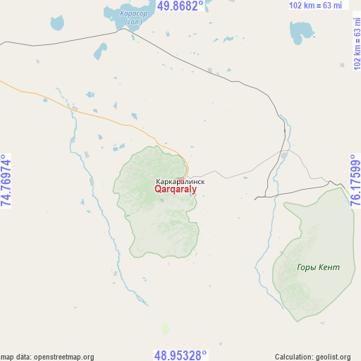
Qarqaraly GPS coordinates[2]
49° 24' 46.332" North, 75° 28' 22.296" East
| Map corner | latitude | longitude |
|---|---|---|
| Upper-left | 49.8682°, | 74.76974° |
| Center: | 49.41287°, | 75.47286° |
| Lower-right: | 48.95328°, | 76.17599° |
| Map W x H: | 101.7×101.7 km | = 63.2×63.2mi |
| max Lat: | 54.90596° ⇑44.8% North |
| Qarqaraly: | 49.41287° |
| min Lat: | ⇓55.2% South 40.66338° |
| min Long | Qarqaraly | max Long |
| 46.83361° | 75.47286° | 84.87144° |
| W 74.8%⇐ | ⇒25.2% E |
Elevation
Elevation of Qarqaraly is 849 m = 2785 ft, and this is 492.5 m = 1616 ft above average elevation for this country.
| Max E: |
1847 m = 6060 ft | 4.1% |
| Qarqaraly | 849 m 2785 ft | |
| Avg. | 356.5 m = 1170 ft | |
Min E: |
-26 m = -85 ft | 95.9% |
See also: Kazakhstan elevation on elevation.city.
Geographical zone
Qarqaraly is located in North temperate zone (between Tropic of Cancer and the Arctic Circle). Distance of this North polar circle is 1907 km =1185 mi to North.| Distance of | km | miles | from Qarqaraly |
|---|---|---|---|
| North Pole | 4512.9 | 2804.2 | to North |
| Arctic Circle | 1907 | 1185 | to North |
| Tropic Cancer | 2888.3 | 1794.7 | to South |
| Equator | 5494.2 | 3413.9 | to South |


Nearby cities:
15 places around Qarqaraly: (largest is in red/bold)
• Abay
190.1 km =118.1 mi,  277°
277°
• Aksu-Ayuly
149.4 km =92.8 mi,  241°
241°
• Aktas
185.5 km =115.3 mi, 282°
• Aktau
195.3 km =121.4 mi,  297°
297°
• Aktogay
139.1 km =86.4 mi,  185°
185°
• Aqshataū
189.3 km =117.6 mi,  213°
213°
• Bayanaul
154.3 km =95.9 mi,  6°
6°
• Karagandy
176.2 km =109.5 mi, 284°
• Koktal
143.6 km =89.2 mi, 280°
• Kushoky
174.2 km =108.2 mi, 301°
• Prigorodnoye
32.1 km =19.9 mi, 14°
• Soran
194.5 km =120.9 mi, 282°
• Temirtau
193.9 km =120.5 mi,  291°
291°
• Tokarevka
183.5 km =114 mi, 295°
• Verkhniye Kayrakty
179 km =111.2 mi, 243°
Sources, notices
• [Note1] Compared only with cities in Kazakhstan existing in our database
• [Src1] Map data: © OpenStreetMap contributors (CC-BY-SA)
• [Src2] Other city data from geonames.org with taken over terms of usage.
• [Src3] Geographical zone / Annual Mean Temperature by Robert A. Rohde @ Wikipedia
