Aksu-Ayuly geodata
Aksu-Ayuly (Karaganda) is a populated place; located in Kazakhstan in Asia/Almaty (GMT+5) time zone. With population of 4,721 people, there are 200 cities with bigger population in this country. Compared to other cities in Kazakhstan, 50.4% of cities are located further ↑North; 69.3% of cities are located further ←West and 91.1% of cities have lower elevation than Aksu-Ayuly. Note1


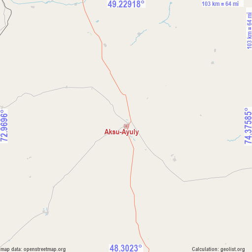
Aksu-Ayuly GPS coordinates[2]
48° 46' 4.368" North, 73° 40' 21.792" East
| Map corner | latitude | longitude |
|---|---|---|
| Upper-left | 49.22918°, | 72.9696° |
| Center: | 48.76788°, | 73.67272° |
| Lower-right: | 48.3023°, | 74.37585° |
| Map W x H: | 103.1×103.1 km | = 64.1×64.1mi |
| max Lat: | 54.90596° ⇑50.4% North |
| Aksu-Ayuly: | 48.76788° |
| min Lat: | ⇓49.6% South 40.66338° |
| min Long | Aksu-Ayuly | max Long |
| 46.83361° | 73.67272° | 84.87144° |
| W 69.3%⇐ | ⇒30.7% E |
Elevation
Elevation of Aksu-Ayuly is 729 m = 2392 ft, and this is 372.5 m = 1222 ft above average elevation for this country.
| Max E: |
1847 m = 6060 ft | 8.9% |
| Aksu-Ayuly | 729 m 2392 ft | |
| Avg. | 356.5 m = 1170 ft | |
Min E: |
-26 m = -85 ft | 91.1% |
See also: Kazakhstan elevation on elevation.city.
Geographical zone
Aksu-Ayuly is located in North temperate zone (between Tropic of Cancer and the Arctic Circle). Distance of this North polar circle is 1978.7 km =1229.5 mi to North.| Distance of | km | miles | from Aksu-Ayuly |
|---|---|---|---|
| North Pole | 4584.6 | 2848.7 | to North |
| Arctic Circle | 1978.7 | 1229.5 | to North |
| Tropic Cancer | 2816.6 | 1750.2 | to South |
| Equator | 5422.5 | 3369.4 | to South |


Nearby cities:
15 places around Aksu-Ayuly: (largest is in red/bold)
• Abay
113.1 km =70.3 mi,  328°
328°
• Aktas
123.8 km =76.9 mi,  335°
335°
• Aktau
102.5 km =63.7 mi,  217°
217°
• Aktogay
137.3 km =85.3 mi,  119°
119°
• Aqadyr
82.4 km =51.2 mi,  226°
226°
• Aqshataū
91.1 km =56.6 mi,  161°
161°
• Dolinka
124.2 km =77.2 mi,  324°
324°
• Karagandy
122.2 km =75.9 mi, 340°
• Koktal
98.7 km =61.3 mi,  353°
353°
• Novodolinskiy
125.7 km =78.1 mi, 326°
• Shakhan
138.3 km =85.9 mi, 327°
• Shakhtinsk
130.8 km =81.3 mi, 323°
• Soran
128.9 km =80.1 mi, 331°
• Verkhniye Kayrakty
30.1 km =18.7 mi,  251°
251°
• Zharyk
62.1 km =38.6 mi,  279°
279°
Sources, notices
• [Note1] Compared only with cities in Kazakhstan existing in our database
• [Src1] Map data: © OpenStreetMap contributors (CC-BY-SA)
• [Src2] Other city data from geonames.org with taken over terms of usage.
• [Src3] Geographical zone / Annual Mean Temperature by Robert A. Rohde @ Wikipedia
