Wattala geodata
Wattala (Western) is a populated place; located in Sri Lanka in Asia/Colombo (GMT+5.5) time zone. With population of 30,725 people, there are 38 cities with bigger population in this country. Compared to other cities in Sri Lanka, 55.3% of cities are located further ↓South; 86.8% of cities are located further →East and 98.7% of cities have higher elevation than Wattala. Note1
Administrative division(s):
- Level 1: Western
- Level 2: Gampaha District
- Level 3: Wattala Division
- Level 4: Telangapatha


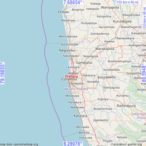
Wattala GPS coordinates[2]
6° 59' 21.048" North, 79° 53' 30.012" East
| Map corner | latitude | longitude |
|---|---|---|
| Upper-left | 7.68654°, | 79.18855° |
| Center: | 6.98918°, | 79.89167° |
| Lower-right: | 6.29078°, | 80.5948° |
| Map W x H: | 155.2×155.2 km | = 96.4×96.4mi |
| max Lat: | 9.81667° ⇑44.7% North |
| Wattala: | 6.98918° |
| min Lat: | ⇓55.3% South 5.92825° |
| min Long | Wattala | max Long |
| 79.79528° | 79.89167° | 81.83472° |
| W 13.2%⇐ | ⇒86.8% E |
Elevation
Elevation of Wattala is 2 m = 7 ft, and this is 155.4 m = 510 ft below average elevation for this country.
| Max E: |
1868 m = 6129 ft | 98.7% |
| Avg. | 157.4 m = 516 ft | |
| Wattala | 2 m = 7 ft | |
Min E: |
1 m = 3 ft | 1.3% |
See also: Sri Lanka elevation on elevation.city.
Geographical zone
Wattala is located in North Torrid zone (between Equator and Tropic of Cancer). Distance of Equator is 777.1 km =482.9 mi to South.| Distance of | km | miles | from Wattala |
|---|---|---|---|
| North Pole | 9229.9 | 5735.2 | to North |
| Arctic Circle | 6624.1 | 4116 | to North |
| Tropic Cancer | 1828.8 | 1136.4 | to North |
| Equator | 777.1 | 482.9 | to South |


Nearby cities:
15 places around Wattala: (largest is in red/bold)
• Battaramulla South
10.7 km =6.6 mi,  164°
164°
• Colombo
7.6 km =4.7 mi,  218°
218°
• Gampaha
15.8 km =9.8 mi,  44°
44°
• Hendala
1 km =0.6 mi,  281°
281°
• Ja Ela
9.5 km =5.9 mi,  0°
0°
• Kandana
6.5 km =4 mi, 1°
• Kelaniya
5 km =3.1 mi,  138°
138°
• Kolonnawa
6.3 km =3.9 mi,  186°
186°
• Kotikawatta
7.2 km =4.5 mi, 164°
• Maharagama
16.2 km =10.1 mi,  166°
166°
• Mulleriyawa
7.5 km =4.7 mi,  146°
146°
• Peliyagoda
2.5 km =1.6 mi,  201°
201°
• Pita Kotte
11 km =6.8 mi, 174°
• Sri Jayewardenepura Kotte
11.9 km =7.4 mi, 171°
• Welisara
4.5 km =2.8 mi,  13°
13°
Sources, notices
• [Note1] Compared only with cities in Sri Lanka existing in our database
• [Src1] Map data: © OpenStreetMap contributors (CC-BY-SA)
• [Src2] Other city data from geonames.org with taken over terms of usage.
• [Src3] Geographical zone / Annual Mean Temperature by Robert A. Rohde @ Wikipedia
