Kotikawatta geodata
Kotikawatta (Western) is a populated place; located in Sri Lanka in Asia/Colombo (GMT+5.5) time zone. With population of 64,565 people, there are 19 cities with bigger population in this country. Compared to other cities in Sri Lanka, 56.6% of cities are located further ↑North; 77.6% of cities are located further →East and 52.6% of cities have higher elevation than Kotikawatta. Note1
Administrative division(s):
- Level 1: Western
- Level 2: Colombo District
- Level 3: Kolonnawa Division
- Level 4: Kajugahawatta


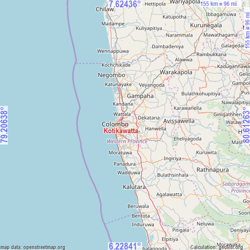
Kotikawatta GPS coordinates[2]
6° 55' 36.84" North, 79° 54' 34.2" East
| Map corner | latitude | longitude |
|---|---|---|
| Upper-left | 7.62436°, | 79.20638° |
| Center: | 6.9269°, | 79.9095° |
| Lower-right: | 6.22841°, | 80.61263° |
| Map W x H: | 155.2×155.2 km | = 96.4×96.4mi |
| max Lat: | 9.81667° ⇑56.6% North |
| Kotikawatta: | 6.9269° |
| min Lat: | ⇓43.4% South 5.92825° |
| min Long | Kotikawatta | max Long |
| 79.79528° | 79.9095° | 81.83472° |
| W 22.4%⇐ | ⇒77.6% E |
Elevation
Elevation of Kotikawatta is 16 m = 52 ft, and this is 141.4 m = 464 ft below average elevation for this country.
| Max E: |
1868 m = 6129 ft | 52.6% |
| Avg. | 157.4 m = 516 ft | |
| Kotikawatta | 16 m = 52 ft | |
Min E: |
1 m = 3 ft | 47.4% |
See also: Kotikawatta elevation on elevation.city.
Geographical zone
Kotikawatta is located in North Torrid zone (between Equator and Tropic of Cancer). Distance of Equator is 770.2 km =478.6 mi to South.| Distance of | km | miles | from Kotikawatta |
|---|---|---|---|
| North Pole | 9236.9 | 5739.5 | to North |
| Arctic Circle | 6631 | 4120.3 | to North |
| Tropic Cancer | 1835.7 | 1140.7 | to North |
| Equator | 770.2 | 478.6 | to South |


Nearby cities:
15 places around Kotikawatta: (largest is in red/bold)
• Battaramulla South
3.5 km =2.2 mi,  164°
164°
• Colombo
6.8 km =4.2 mi,  278°
278°
• Dehiwala-Mount Lavinia
10.5 km =6.5 mi,  203°
203°
• Hendala
7.7 km =4.8 mi,  337°
337°
• Homagama
13.8 km =8.6 mi,  131°
131°
• Kandana
13.6 km =8.5 mi,  352°
352°
• Kelaniya
3.4 km =2.1 mi,  23°
23°
• Kolonnawa
2.8 km =1.7 mi, 283°
• Maharagama
9 km =5.6 mi,  167°
167°
• Mulleriyawa
2.3 km =1.4 mi,  73°
73°
• Peliyagoda
5.4 km =3.4 mi,  328°
328°
• Pita Kotte
4.1 km =2.5 mi,  192°
192°
• Sri Jayewardenepura Kotte
4.9 km =3 mi,  183°
183°
• Wattala
7.2 km =4.5 mi, 344°
• Welisara
11.3 km =7 mi,  355°
355°
Sources, notices
• [Note1] Compared only with cities in Sri Lanka existing in our database
• [Src1] Map data: © OpenStreetMap contributors (CC-BY-SA)
• [Src2] Other city data from geonames.org with taken over terms of usage.
• [Src3] Geographical zone / Annual Mean Temperature by Robert A. Rohde @ Wikipedia
