Kandana geodata
Kandana (Western) is a populated place; located in Sri Lanka in Asia/Colombo (GMT+5.5) time zone. With population of 33,424 people, there are 36 cities with bigger population in this country. Compared to other cities in Sri Lanka, 59.2% of cities are located further ↓South; 84.2% of cities are located further →East and 78.9% of cities have higher elevation than Kandana. Note1


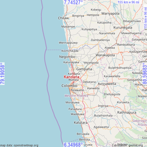
Kandana GPS coordinates[2]
7° 2' 52.8" North, 79° 53' 37.32" East
| Map corner | latitude | longitude |
|---|---|---|
| Upper-left | 7.74527°, | 79.19058° |
| Center: | 7.048°, | 79.8937° |
| Lower-right: | 6.34968°, | 80.59683° |
| Map W x H: | 155.2×155.2 km | = 96.4×96.4mi |
| max Lat: | 9.81667° ⇑40.8% North |
| Kandana: | 7.048° |
| min Lat: | ⇓59.2% South 5.92825° |
| min Long | Kandana | max Long |
| 79.79528° | 79.8937° | 81.83472° |
| W 15.8%⇐ | ⇒84.2% E |
Elevation
Elevation of Kandana is 9 m = 30 ft, and this is 148.4 m = 487 ft below average elevation for this country.
| Max E: |
1868 m = 6129 ft | 78.9% |
| Avg. | 157.4 m = 516 ft | |
| Kandana | 9 m = 30 ft | |
Min E: |
1 m = 3 ft | 21.1% |
See also: Sri Lanka elevation on elevation.city.
Geographical zone
Kandana is located in North Torrid zone (between Equator and Tropic of Cancer). Distance of Equator is 783.7 km =487 mi to South.| Distance of | km | miles | from Kandana |
|---|---|---|---|
| North Pole | 9223.4 | 5731.2 | to North |
| Arctic Circle | 6617.5 | 4111.9 | to North |
| Tropic Cancer | 1822.3 | 1132.3 | to North |
| Equator | 783.7 | 487 | to South |


Nearby cities:
15 places around Kandana: (largest is in red/bold)
• Battaramulla South
17.1 km =10.6 mi,  170°
170°
• Colombo
13.5 km =8.4 mi,  201°
201°
• Gampaha
11.8 km =7.3 mi,  66°
66°
• Hendala
6.5 km =4 mi,  190°
190°
• Ja Ela
2.9 km =1.8 mi,  356°
356°
• Katunayaka
13.6 km =8.5 mi, 357°
• Kelaniya
10.8 km =6.7 mi,  163°
163°
• Kolonnawa
12.8 km =8 mi,  184°
184°
• Kotikawatta
13.6 km =8.5 mi, 172°
• Minuwangoda
14.7 km =9.1 mi,  26°
26°
• Mulleriyawa
13.4 km =8.3 mi, 162°
• Peliyagoda
8.9 km =5.5 mi, 187°
• Pita Kotte
17.5 km =10.9 mi, 177°
• Wattala
6.5 km =4 mi, 181°
• Welisara
2.4 km =1.5 mi, 158°
Sources, notices
• [Note1] Compared only with cities in Sri Lanka existing in our database
• [Src1] Map data: © OpenStreetMap contributors (CC-BY-SA)
• [Src2] Other city data from geonames.org with taken over terms of usage.
• [Src3] Geographical zone / Annual Mean Temperature by Robert A. Rohde @ Wikipedia
