Gampaha geodata
Gampaha (Western) is a populated place; located in Sri Lanka in Asia/Colombo (GMT+5.5) time zone. With population of 9,350 people, there are 59 cities with bigger population in this country. Compared to other cities in Sri Lanka, 61.8% of cities are located further ↓South; 67.1% of cities are located further →East and 57.9% of cities have lower elevation than Gampaha. Note1
Administrative division(s):
- Level 1: Western
- Level 2: Gampaha District
- Level 3: Gampaha Division
- Level 4: Medagama II


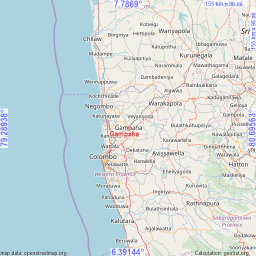
Gampaha GPS coordinates[2]
7° 5' 22.92" North, 79° 59' 33" East
| Map corner | latitude | longitude |
|---|---|---|
| Upper-left | 7.7869°, | 79.28938° |
| Center: | 7.0897°, | 79.9925° |
| Lower-right: | 6.39144°, | 80.69563° |
| Map W x H: | 155.2×155.2 km | = 96.4×96.4mi |
| max Lat: | 9.81667° ⇑38.2% North |
| Gampaha: | 7.0897° |
| min Lat: | ⇓61.8% South 5.92825° |
| min Long | Gampaha | max Long |
| 79.79528° | 79.9925° | 81.83472° |
| W 32.9%⇐ | ⇒67.1% E |
Elevation
Elevation of Gampaha is 21 m = 69 ft, and this is 136.4 m = 448 ft below average elevation for this country.
| Max E: |
1868 m = 6129 ft | 42.1% |
| Avg. | 157.4 m = 516 ft | |
| Gampaha | 21 m = 69 ft | |
Min E: |
1 m = 3 ft | 57.9% |
See also: Sri Lanka elevation on elevation.city.
Geographical zone
Gampaha is located in North Torrid zone (between Equator and Tropic of Cancer). Distance of Equator is 788.3 km =489.8 mi to South.| Distance of | km | miles | from Gampaha |
|---|---|---|---|
| North Pole | 9218.8 | 5728.3 | to North |
| Arctic Circle | 6612.9 | 4109.1 | to North |
| Tropic Cancer | 1817.6 | 1129.4 | to North |
| Equator | 788.3 | 489.8 | to South |


Nearby cities:
15 places around Gampaha: (largest is in red/bold)
• Battaramulla South
23 km =14.3 mi,  200°
200°
• Hanwella Ihala
23.3 km =14.5 mi,  153°
153°
• Hendala
16.3 km =10.1 mi,  227°
227°
• Ja Ela
11.2 km =7 mi,  261°
261°
• Kandana
11.8 km =7.3 mi,  246°
246°
• Katunayaka
14.5 km =9 mi,  307°
307°
• Kelaniya
16.8 km =10.4 mi,  207°
207°
• Kolonnawa
21.1 km =13.1 mi, 214°
• Kotikawatta
20.3 km =12.6 mi, 206°
• Minuwangoda
9.6 km =6 mi,  333°
333°
• Mulleriyawa
18.8 km =11.7 mi, 201°
• Negombo
21.7 km =13.5 mi, 307°
• Peliyagoda
18.1 km =11.2 mi,  221°
221°
• Wattala
15.8 km =9.8 mi, 224°
• Welisara
12.2 km =7.6 mi,  235°
235°
Sources, notices
• [Note1] Compared only with cities in Sri Lanka existing in our database
• [Src1] Map data: © OpenStreetMap contributors (CC-BY-SA)
• [Src2] Other city data from geonames.org with taken over terms of usage.
• [Src3] Geographical zone / Annual Mean Temperature by Robert A. Rohde @ Wikipedia
