Dehiwala-Mount Lavinia geodata
Dehiwala-Mount Lavinia (Western) is a populated place; located in Sri Lanka in Asia/Colombo (GMT+5.5) time zone. With population of 219,827 people, there is 1 city with bigger population in this country. Compared to other cities in Sri Lanka, 69.7% of cities are located further ↑North; 94.7% of cities are located further →East and 52.6% of cities have higher elevation than Dehiwala-Mount Lavinia. Note1
Current local time in Dehiwala-Mount Lavinia:
05:12 PM, WednesdayDifference from your time zone: hours


Dehiwala-Mount Lavinia GPS coordinates[2]
6° 50' 24.684" North, 79° 52' 16.176" East
| Map corner | latitude | longitude |
|---|---|---|
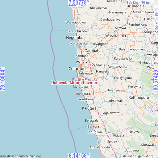
| Upper-left | 7.53778°, | 79.16804° |
| Center: | 6.84019°, | 79.87116° |
| Lower-right: | 6.14158°, | 80.57429° |
| Map W x H: | 155.2×155.2 km | = 96.4×96.4mi |
| max Lat: | 9.81667° ⇑69.7% North |
| Dehiwala-Mount Lavinia: | 6.84019° |
| min Lat: | ⇓30.3% South 5.92825° |
| min Long | Dehiwala-Mount | max Long |
| 79.79528° | 79.87116° | 81.83472° |
| W 5.3%⇐ | ⇒94.7% E |
Elevation
Elevation of Dehiwala-Mount Lavinia is 16 m = 52 ft, and this is 141.4 m = 464 ft below average elevation for this country.
| Max E: |
1868 m = 6129 ft | 52.6% |
| Avg. | 157.4 m = 516 ft | |
| Dehiwala-Mount Lavinia | 16 m = 52 ft | |
Min E: |
1 m = 3 ft | 47.4% |
See also: Dehiwala-Mount Lavinia elevation on elevation.city.
Geographical zone
Dehiwala-Mount Lavinia is located in North Torrid zone (between Equator and Tropic of Cancer). Distance of Equator is 760.6 km =472.6 mi to South.| Distance of | km | miles | from Dehiwala-Mount Lavinia |
|---|---|---|---|
| North Pole | 9246.5 | 5745.5 | to North |
| Arctic Circle | 6640.6 | 4126.3 | to North |
| Tropic Cancer | 1845.4 | 1146.7 | to North |
| Equator | 760.6 | 472.6 | to South |


Nearby cities:
15 places around Dehiwala-Mount Lavinia: (largest is in red/bold)
• Battaramulla South
8.1 km =5 mi,  39°
39°
• Colombo
10.9 km =6.8 mi,  346°
346°
• Hendala
16.8 km =10.4 mi,  4°
4°
• Homagama
14.5 km =9 mi,  88°
88°
• Kelaniya
14 km =8.7 mi,  23°
23°
• Kolonnawa
10.4 km =6.5 mi,  8°
8°
• Kotikawatta
10.5 km =6.5 mi, 23°
• Maharagama
6.2 km =3.9 mi,  81°
81°
• Moratuwa
7.6 km =4.7 mi,  171°
171°
• Mulleriyawa
12.2 km =7.6 mi,  32°
32°
• Panadura
14.5 km =9 mi, 166°
• Peliyagoda
14.3 km =8.9 mi, 5°
• Pita Kotte
6.5 km =4 mi, 30°
• Sri Jayewardenepura Kotte
6.2 km =3.9 mi, 39°
• Wattala
16.7 km =10.4 mi, 7°
Sources, notices
• [Note1] Compared only with cities in Sri Lanka existing in our database
• [Src1] Map data: © OpenStreetMap contributors (CC-BY-SA)
• [Src2] Other city data from geonames.org with taken over terms of usage.
• [Src3] Geographical zone / Annual Mean Temperature by Robert A. Rohde @ Wikipedia
