Homagama geodata
Homagama (Western) is a populated place; located in Sri Lanka in Asia/Colombo (GMT+5.5) time zone. With population of 34,664 people, there are 32 cities with bigger population in this country. Compared to other cities in Sri Lanka, 68.4% of cities are located further ↑North; 64.5% of cities are located further →East and 67.1% of cities have lower elevation than Homagama. Note1
Administrative division(s):
- Level 1: Western
- Level 2: Colombo District
- Level 3: Homagama Division
- Level 4: Homagama Town


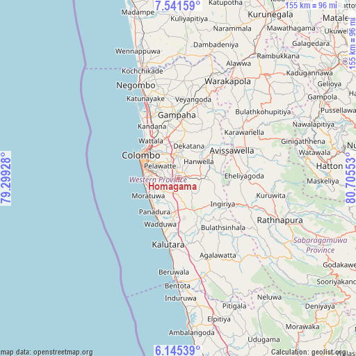
Homagama GPS coordinates[2]
6° 50' 38.4" North, 80° 0' 8.64" East
| Map corner | latitude | longitude |
|---|---|---|
| Upper-left | 7.54159°, | 79.29928° |
| Center: | 6.844°, | 80.0024° |
| Lower-right: | 6.14539°, | 80.70553° |
| Map W x H: | 155.2×155.2 km | = 96.4×96.4mi |
| max Lat: | 9.81667° ⇑68.4% North |
| Homagama: | 6.844° |
| min Lat: | ⇓31.6% South 5.92825° |
| min Long | Homagama | max Long |
| 79.79528° | 80.0024° | 81.83472° |
| W 35.5%⇐ | ⇒64.5% E |
Elevation
Elevation of Homagama is 37 m = 121 ft, and this is 120.4 m = 395 ft below average elevation for this country.
| Max E: |
1868 m = 6129 ft | 32.9% |
| Avg. | 157.4 m = 516 ft | |
| Homagama | 37 m = 121 ft | |
Min E: |
1 m = 3 ft | 67.1% |
See also: Sri Lanka elevation on elevation.city.
Geographical zone
Homagama is located in North Torrid zone (between Equator and Tropic of Cancer). Distance of Equator is 761 km =472.9 mi to South.| Distance of | km | miles | from Homagama |
|---|---|---|---|
| North Pole | 9246.1 | 5745.3 | to North |
| Arctic Circle | 6640.2 | 4126 | to North |
| Tropic Cancer | 1844.9 | 1146.4 | to North |
| Equator | 761 | 472.9 | to South |


Nearby cities:
15 places around Homagama: (largest is in red/bold)
• Battaramulla South
11 km =6.8 mi,  302°
302°
• Colombo
19.8 km =12.3 mi, 300°
• Dehiwala-Mount Lavinia
14.5 km =9 mi,  268°
268°
• Hanwella Ihala
11.1 km =6.9 mi,  55°
55°
• Horana South
15.7 km =9.8 mi,  154°
154°
• Kelaniya
15.2 km =9.4 mi,  324°
324°
• Kolonnawa
16.3 km =10.1 mi,  307°
307°
• Kotikawatta
13.8 km =8.6 mi, 311°
• Maharagama
8.4 km =5.2 mi, 273°
• Moratuwa
15.5 km =9.6 mi,  239°
239°
• Mulleriyawa
12.7 km =7.9 mi, 320°
• Panadura
18.2 km =11.3 mi,  217°
217°
• Peliyagoda
19.1 km =11.9 mi, 316°
• Pita Kotte
12.3 km =7.6 mi,  294°
294°
• Sri Jayewardenepura Kotte
11.4 km =7.1 mi, 292°
Sources, notices
• [Note1] Compared only with cities in Sri Lanka existing in our database
• [Src1] Map data: © OpenStreetMap contributors (CC-BY-SA)
• [Src2] Other city data from geonames.org with taken over terms of usage.
• [Src3] Geographical zone / Annual Mean Temperature by Robert A. Rohde @ Wikipedia
