Horana South geodata
Horana South (Western) is a populated place; located in Sri Lanka in Asia/Colombo (GMT+5.5) time zone. With population of 8,982 people, there are 60 cities with bigger population in this country. Compared to other cities in Sri Lanka, 76.3% of cities are located further ↑North; 59.2% of cities are located further →East and 60.5% of cities have lower elevation than Horana South. Note1
Administrative division(s):
- Level 1: Western
- Level 2: Kalutara District
- Level 3: Horana Division
- Level 4: Horana South


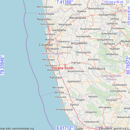
Horana South GPS coordinates[2]
6° 42' 57.24" North, 80° 3' 45.36" East
| Map corner | latitude | longitude |
|---|---|---|
| Upper-left | 7.41368°, | 79.35948° |
| Center: | 6.7159°, | 80.0626° |
| Lower-right: | 6.01712°, | 80.76573° |
| Map W x H: | 155.3×155.3 km | = 96.5×96.5mi |
| max Lat: | 9.81667° ⇑76.3% North |
| Horana South: | 6.7159° |
| min Lat: | ⇓23.7% South 5.92825° |
| min Long | Horana South | max Long |
| 79.79528° | 80.0626° | 81.83472° |
| W 40.8%⇐ | ⇒59.2% E |
Elevation
Elevation of Horana South is 23 m = 75 ft, and this is 134.4 m = 441 ft below average elevation for this country.
| Max E: |
1868 m = 6129 ft | 39.5% |
| Avg. | 157.4 m = 516 ft | |
| Horana South | 23 m = 75 ft | |
Min E: |
1 m = 3 ft | 60.5% |
See also: Sri Lanka elevation on elevation.city.
Geographical zone
Horana South is located in North Torrid zone (between Equator and Tropic of Cancer). Distance of Equator is 746.7 km =464 mi to South.| Distance of | km | miles | from Horana South |
|---|---|---|---|
| North Pole | 9260.3 | 5754.1 | to North |
| Arctic Circle | 6654.4 | 4134.9 | to North |
| Tropic Cancer | 1859.2 | 1155.3 | to North |
| Equator | 746.7 | 464 | to South |


Nearby cities:
15 places around Horana South: (largest is in red/bold)
• Battaramulla South
25.6 km =15.9 mi,  321°
321°
• Beruwala
27.8 km =17.3 mi,  198°
198°
• Dehiwala-Mount Lavinia
25.3 km =15.7 mi,  303°
303°
• Hanwella Ihala
20.8 km =12.9 mi,  6°
6°
• Homagama
15.7 km =9.8 mi,  334°
334°
• Horawala Junction
27.1 km =16.8 mi,  164°
164°
• Kalutara
18.7 km =11.6 mi,  217°
217°
• Kelaniya
30.8 km =19.1 mi, 329°
• Kotikawatta
28.9 km =18 mi, 324°
• Maharagama
21 km =13 mi,  314°
314°
• Moratuwa
21 km =13 mi,  287°
287°
• Mulleriyawa
28.2 km =17.5 mi, 328°
• Panadura
17.7 km =11 mi,  269°
269°
• Pita Kotte
26.3 km =16.3 mi, 317°
• Sri Jayewardenepura Kotte
25.3 km =15.7 mi, 317°
Sources, notices
• [Note1] Compared only with cities in Sri Lanka existing in our database
• [Src1] Map data: © OpenStreetMap contributors (CC-BY-SA)
• [Src2] Other city data from geonames.org with taken over terms of usage.
• [Src3] Geographical zone / Annual Mean Temperature by Robert A. Rohde @ Wikipedia
