Horawala Junction geodata
Horawala Junction (Western) is a populated place; located in Sri Lanka in Asia/Colombo (GMT+5.5) time zone. With population of 7,500 people, there are 63 cities with bigger population in this country. Compared to other cities in Sri Lanka, 81.6% of cities are located further ↑North; 55.3% of cities are located further →East and 53.9% of cities have higher elevation than Horawala Junction. Note1
Administrative division(s):
- Level 1: Western
- Level 2: Kalutara District
- Level 3: Matugama Division
- Level 4: Horawala West


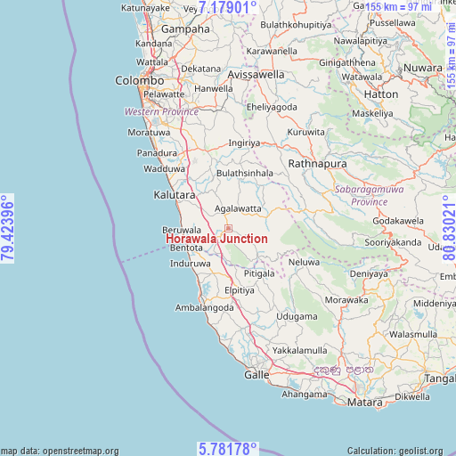
Horawala Junction GPS coordinates[2]
6° 28' 51.168" North, 80° 7' 37.488" East
| Map corner | latitude | longitude |
|---|---|---|
| Upper-left | 7.17901°, | 79.42396° |
| Center: | 6.48088°, | 80.12708° |
| Lower-right: | 5.78178°, | 80.83021° |
| Map W x H: | 155.4×155.4 km | = 96.6×96.6mi |
| max Lat: | 9.81667° ⇑81.6% North |
| Horawala Junction: | 6.48088° |
| min Lat: | ⇓18.4% South 5.92825° |
| min Long | Horawala Juncti | max Long |
| 79.79528° | 80.12708° | 81.83472° |
| W 44.7%⇐ | ⇒55.3% E |
Elevation
Elevation of Horawala Junction is 15 m = 49 ft, and this is 142.4 m = 467 ft below average elevation for this country.
| Max E: |
1868 m = 6129 ft | 53.9% |
| Avg. | 157.4 m = 516 ft | |
| Horawala Junction | 15 m = 49 ft | |
Min E: |
1 m = 3 ft | 46.1% |
See also: Sri Lanka elevation on elevation.city.
Geographical zone
Horawala Junction is located in North Torrid zone (between Equator and Tropic of Cancer). Distance of Equator is 720.6 km =447.8 mi to South.| Distance of | km | miles | from Horawala Junction |
|---|---|---|---|
| North Pole | 9286.5 | 5770.4 | to North |
| Arctic Circle | 6680.6 | 4151.1 | to North |
| Tropic Cancer | 1885.3 | 1171.5 | to North |
| Equator | 720.6 | 447.8 | to South |


Nearby cities:
15 places around Horawala Junction: (largest is in red/bold)
• Ambalangoda
28.5 km =17.7 mi,  196°
196°
• Bentota
15.7 km =9.8 mi,  247°
247°
• Beruwala
15.9 km =9.9 mi,  269°
269°
• Dehiwala-Mount Lavinia
48.9 km =30.4 mi,  324°
324°
• Galle
49.2 km =30.6 mi,  169°
169°
• Hanwella Ihala
47 km =29.2 mi,  354°
354°
• Hikkaduwa
37.9 km =23.5 mi,  184°
184°
• Homagama
42.7 km =26.5 mi,  341°
341°
• Horana South
27.1 km =16.8 mi, 344°
• Kalutara
21.7 km =13.5 mi,  301°
301°
• Maharagama
46.4 km =28.8 mi,  331°
331°
• Moratuwa
42.3 km =26.3 mi, 320°
• Panadura
35.8 km =22.2 mi, 316°
• Ratnapura
38.1 km =23.7 mi,  53°
53°
• Sri Jayewardenepura Kotte
50.9 km =31.6 mi, 331°
Sources, notices
• [Note1] Compared only with cities in Sri Lanka existing in our database
• [Src1] Map data: © OpenStreetMap contributors (CC-BY-SA)
• [Src2] Other city data from geonames.org with taken over terms of usage.
• [Src3] Geographical zone / Annual Mean Temperature by Robert A. Rohde @ Wikipedia
