Gelgaudiškis geodata
Gelgaudiškis (Marijampolė County) is a populated place; located in Lithuania in Europe/Vilnius (GMT+3) time zone. With population of 1,839 people, there are 98 cities with bigger population in this country. Compared to other cities in Lithuania, 51.5% of cities are located further ↑North; 72.4% of cities are located further →East and 80.6% of cities have higher elevation than Gelgaudiškis. Note1


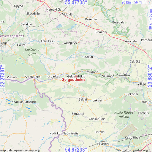
Gelgaudiškis GPS coordinates[2]
55° 4' 36.768" North, 22° 58' 37.164" East
| Map corner | latitude | longitude |
|---|---|---|
| Upper-left | 55.47738°, | 22.27387° |
| Center: | 55.07688°, | 22.97699° |
| Lower-right: | 54.67233°, | 23.68012° |
| Map W x H: | 89.5×89.5 km | = 55.6×55.6mi |
| max Lat: | 56.36149° ⇑51.5% North |
| Gelgaudiškis: | 55.07688° |
| min Lat: | ⇓48.5% South 54.01573° |
| min Long | Gelgaudiškis | max Long |
| 20.99651° | 22.97699° | 26.43984° |
| W 27.6%⇐ | ⇒72.4% E |
Elevation
Elevation of Gelgaudiškis is 53 m = 174 ft, and this is 37.7 m = 124 ft below average elevation for this country.
| Max E: |
204 m = 669 ft | 80.6% |
| Avg. | 90.7 m = 298 ft | |
| Gelgaudiškis | 53 m = 174 ft | |
Min E: |
-1 m = -3 ft | 19.4% |
See also: Lithuania elevation on elevation.city.
Geographical zone
Gelgaudiškis is located in North temperate zone (between Tropic of Cancer and the Arctic Circle). Distance of this North polar circle is 1277.2 km =793.6 mi to North.| Distance of | km | miles | from Gelgaudiškis |
|---|---|---|---|
| North Pole | 3883.1 | 2412.8 | to North |
| Arctic Circle | 1277.2 | 793.6 | to North |
| Tropic Cancer | 3518.1 | 2186 | to South |
| Equator | 6124 | 3805.3 | to South |


Nearby cities:
15 places around Gelgaudiškis: (largest is in red/bold)
• Ariogala
37.8 km =23.5 mi,  57°
57°
• Būgai
44.1 km =27.4 mi,  328°
328°
• Ežerėlis
45.4 km =28.2 mi,  118°
118°
• Jurbarkas
13.5 km =8.4 mi,  269°
269°
• Kazlų Rūda
49 km =30.4 mi,  138°
138°
• Kačerginė
49.8 km =30.9 mi,  108°
108°
• Kudirkos Naumiestis
34.5 km =21.4 mi,  192°
192°
• Kulautuva
45 km =28 mi, 109°
• Kybartai
50.6 km =31.4 mi,  195°
195°
• Raseiniai
34.9 km =21.7 mi,  15°
15°
• Smalininkai
25 km =15.5 mi, 269°
• Taurage
47.8 km =29.7 mi,  294°
294°
• Vilkaviskis
47.4 km =29.5 mi,  175°
175°
• Vilkija
38.9 km =24.2 mi,  95°
95°
• Šakiai
14.5 km =9 mi,  161°
161°
Sources, notices
• [Note1] Compared only with cities in Lithuania existing in our database
• [Src1] Map data: © OpenStreetMap contributors (CC-BY-SA)
• [Src2] Other city data from geonames.org with taken over terms of usage.
• [Src3] Geographical zone / Annual Mean Temperature by Robert A. Rohde @ Wikipedia
