Ariogala geodata
Ariogala (Kaunas) is a populated place; located in Lithuania in Europe/Vilnius (GMT+3) time zone. With population of 3,653 people, there are 77 cities with bigger population in this country. Compared to other cities in Lithuania, 55.2% of cities are located further ↓South; 65.7% of cities are located further →East and 51.5% of cities have higher elevation than Ariogala. Note1


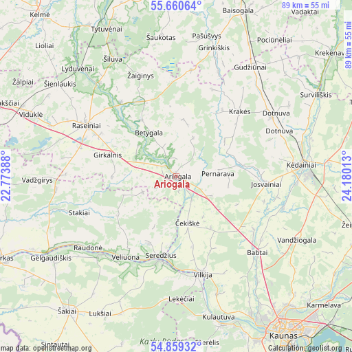
Ariogala GPS coordinates[2]
55° 15' 43.2" North, 23° 28' 37.2" East
| Map corner | latitude | longitude |
|---|---|---|
| Upper-left | 55.66064°, | 22.77388° |
| Center: | 55.262°, | 23.477° |
| Lower-right: | 54.85932°, | 24.18013° |
| Map W x H: | 89.1×89.1 km | = 55.4×55.4mi |
| max Lat: | 56.36149° ⇑44.8% North |
| Ariogala: | 55.262° |
| min Lat: | ⇓55.2% South 54.01573° |
| min Long | Ariogala | max Long |
| 20.99651° | 23.477° | 26.43984° |
| W 34.3%⇐ | ⇒65.7% E |
Elevation
Elevation of Ariogala is 80 m = 262 ft, and this is 10.7 m = 35 ft below average elevation for this country.
| Max E: |
204 m = 669 ft | 51.5% |
| Avg. | 90.7 m = 298 ft | |
| Ariogala | 80 m = 262 ft | |
Min E: |
-1 m = -3 ft | 48.5% |
See also: Lithuania elevation on elevation.city.
Geographical zone
Ariogala is located in North temperate zone (between Tropic of Cancer and the Arctic Circle). Distance of this North polar circle is 1256.6 km =780.8 mi to North.| Distance of | km | miles | from Ariogala |
|---|---|---|---|
| North Pole | 3862.5 | 2400 | to North |
| Arctic Circle | 1256.6 | 780.8 | to North |
| Tropic Cancer | 3538.6 | 2198.8 | to South |
| Equator | 6144.6 | 3818.1 | to South |


Nearby cities:
15 places around Ariogala: (largest is in red/bold)
• Akademija (Kaunas)
46.3 km =28.8 mi,  151°
151°
• Dotnuva
28.3 km =17.6 mi,  65°
65°
• Eiguliai
46.8 km =29.1 mi,  141°
141°
• Ežerėlis
42.9 km =26.7 mi,  169°
169°
• Gelgaudiškis
37.8 km =23.5 mi,  237°
237°
• Kačerginė
39.6 km =24.6 mi,  157°
157°
• Kulautuva
37.1 km =23.1 mi, 163°
• Kėdainiai
31.5 km =19.6 mi,  84°
84°
• Noreikiškės
47.9 km =29.8 mi, 150°
• Raseiniai
25.9 km =16.1 mi,  300°
300°
• Sargėnai
43.3 km =26.9 mi, 143°
• Tytuvėnėliai
44.6 km =27.7 mi,  334°
334°
• Vilkija
25 km =15.5 mi, 163°
• Šakiai
43.8 km =27.2 mi,  218°
218°
• Šilainiai
45.2 km =28.1 mi, 144°
Sources, notices
• [Note1] Compared only with cities in Lithuania existing in our database
• [Src1] Map data: © OpenStreetMap contributors (CC-BY-SA)
• [Src2] Other city data from geonames.org with taken over terms of usage.
• [Src3] Geographical zone / Annual Mean Temperature by Robert A. Rohde @ Wikipedia
